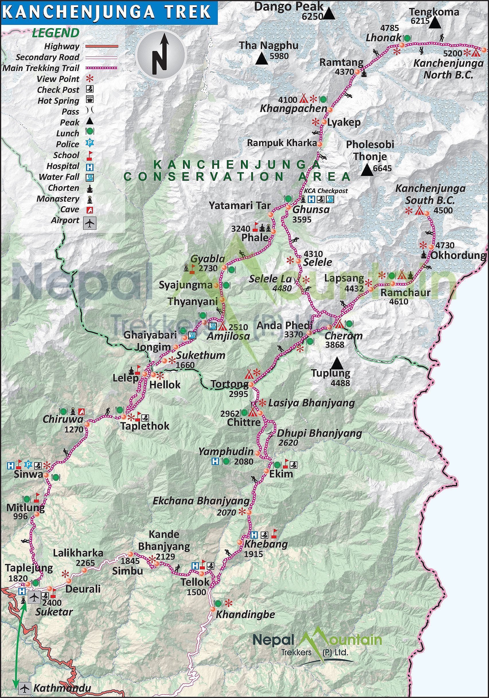
Our route was the orange line

Participants: Derek, Sangey (lot’s of enthusiasm, an angel of a man, did not know the way and understood 15% of what I said, always ready with hot tea), Kamsing (porter and cook, great guy), Dawa (Patrick Swazey of Nepal with his faux leather jacket)
October 10, 2013
So here I am again, it is hard to believe that a year has gone by so fast. I left Calgary at 9.30 pm on October 8th on a BA flight to London. It took me two days to get to Kathmandu. The flight was much easier than last year due to the Dubai detour. Calgary was hard to leave as always and everyone was sad to see me go for a month again. I was sad to make everyone sad. Johnny was the best about it. He is a great kid and I could not ask for a better blessing in my life. Once we all got over the collective sadness I went to the airport. All went very smooth. In London, I met with David and we went to central London. I seem to experience London in bits and pieces over the years. It is a true anthill. Seeing the mass of grey suits move through the subway tunnels, all the people just running and rushing oblivious to their conditioning, it is like the end scene from the 1st Matrix movie that I just watched with Johnny before I left.
The flight to Kathmandu went quick and at 5pm I was there. Rajendra met me at the airport and we drove to the Nirvana Garden Hotel, my home away from home. The same day, I went to Kumar’s for dinner. He of course made the Dhal Baht. I met with Ashok and Anupa again and gave them the small gifts I brought from Canada. They showed me their schoolwork. They are making good progress with English, as I can actually talk to them now. The kids seem good and I am happy that I can be of help to them. I was very tired so I just crashed and was up at 4.30 am due to the jet lag.
It is 5 am now in Kathmandu and it is Friday. I am sitting in a room in the Nirvana Garden Hotel – the favorite of Rajendra.

October 11, 2013
Early in the morning I took a walk around the Dubar Square. So it happens that I am here at the same time as last year and the festival of Dashan is taking place. I already saw dead goats and many waiting to die.
I took an early morning (9 am) Yeti Airlines flight to Briatnagar, the second largest city in Nepal in the southeast corner of the country. I had a beautiful view of the Himalayas again all the way from Shishapagma to Kanchendzonga. The flight takes 25 minutes. It was very satisfying to realize that I walked through a large portion of this distance. I arrived in Biratnagar and I parked myself in the cafeteria at the airport waiting for Sangey who was already 1 hour late. At this point I was not sure what was going on as the guide and the crew were not here to meet me. The good news is that Tapeljung (the starting point of the trek) is only 6 hours away, apparently on a good road.

I also have 100,000 Rs emergency cash from Rajendra for Sangey. It all feels very loosy goosy, not what I am used to but I will go with the flow. Everything seems to be fluid and flexible here this time around. I am used to this by now.
October 12, 2013 Somewhere in Southeast Nepal 100m
Sangey, Kam and Dawa showed up at the canteen at the airport eventually. It was really hot 35C and humid. We took a rickshaw from the airport to a small guesthouse on the airport road 15 minutes away. We needed to find a way to get to Tumlingtar. The asking price was $350 which was quite expensive so the decision was made to go half way and try our luck from there.
The ride to the town at half way point was 3 hours. It was hot and not very comfortable in a small car but the road was good. The town was like all the small Terai towns I have seen so far. All the hotels were full because of the festival of Dashan so we stayed at a place of last resort. A filthy concrete guesthouse with bed bugs. I had to put the ground sheet from my tent on the bed before I put my sleeping bag on it. The sheets, which are never changed, had bloodstains on them. Kam and Dawa do not speak English. Sangey’s English is rudimentary at best making my conversations very limited. They are all very nice though and Sangey tries so hard to be a good guide. It will be a very meditative month if I do not run into any Westerners.

October 13, 2013 Suketar 2450m
We took another car arranged by the hotel owner from the small town we stayed in to Suketar, the trek’s starting point (where the old airport was at one point in time). The airstrip in Suketar is still there but there are no more flights. On the way we climbed up the hills of eastern Nepal covered in tea plantations. The beautiful views in clear weather extended all the way to the Kanjendzonga massif. All three Kanj peaks, Janu and other mountains were clearly visible. In the distance, we could see the Everest group, Makalu and Chamlang were well visible as well. It was very hot on the way.
We arrived in Suketar and checked into the Everest View Hotel without the Everest view. Actually in the afternoon, the clouds rolled in and obscured all views. The trip so far was much more relaxed than last year. It all seemed very fluid, we had no fixed itinerary and I was not sure if anyone in my little group knew the way to our destination (they did not). It seemed that we would all rely on the large scale map that I bought in Kathmandu before we left. In Nepal, when it all seems hopeless, somehow it all works out at the end. I decided to let things just happen and we would figure it out eventually. In retrospect, a very good decision.
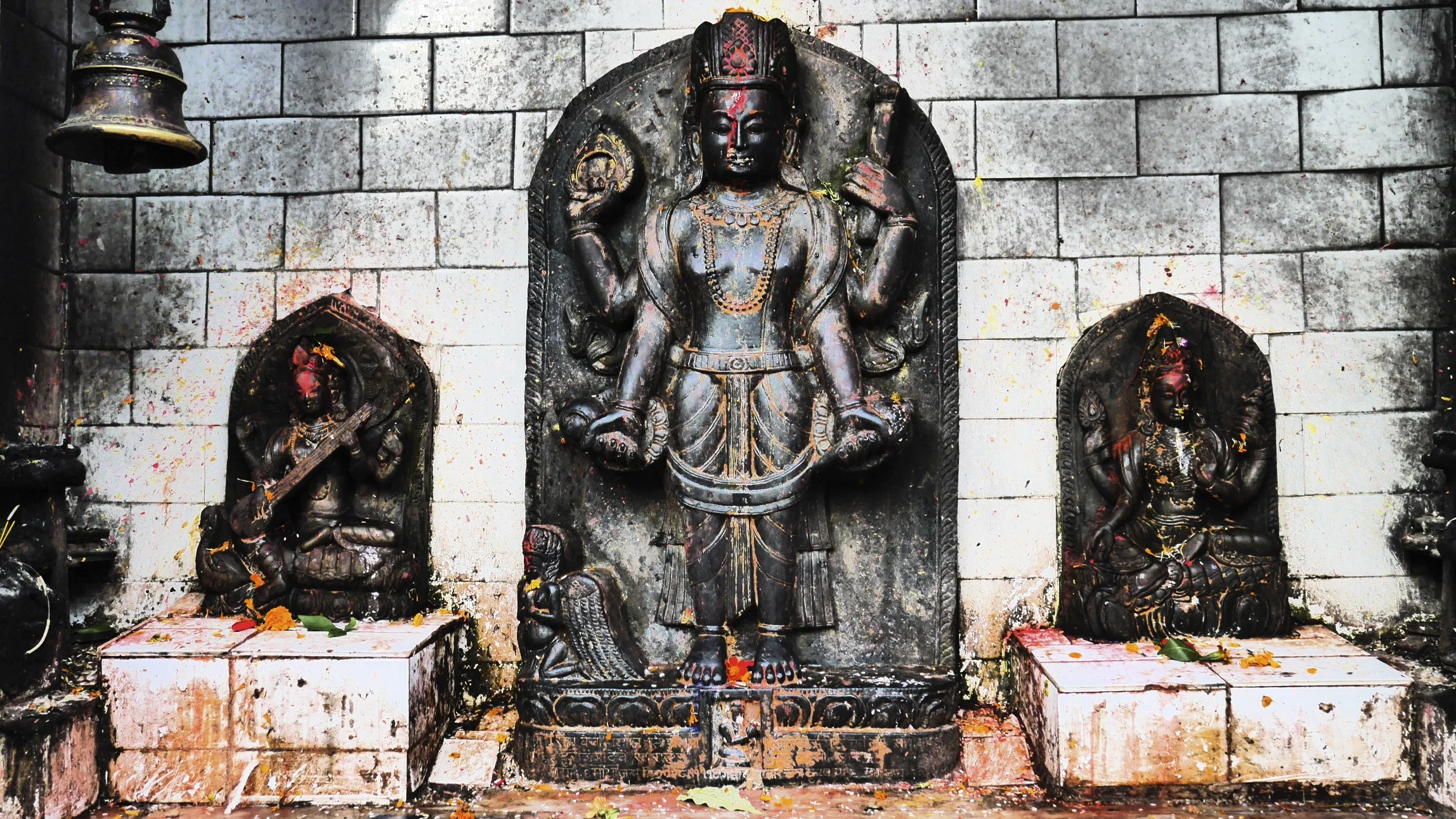
In the afternoon, after dinner, I took a walk to the abandoned airstrip in Suketar. It was somewhat erie. Next to the airstrip, there was an old Hindu shrine. From the shrine, there was a nice view over the hills of eastern Nepal with green hills spreading below me. For dinner we had momos and chow main. I am glad that I brought my own snacks as eating Dhal Baht every day would get tiring.
October 14, 2013
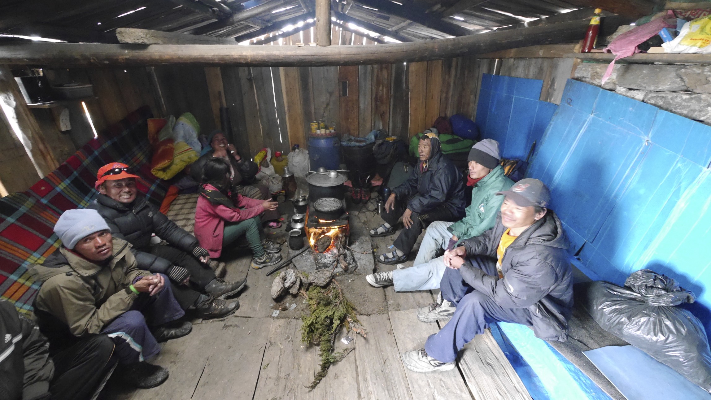
We got up at 5 am, and started walking at 7.30 am. The sky was overcast and it started to rain soon after we left. It is one of those miserable days with lots of rain, making the experience not very enjoyable. The trail started on a road, which was quite easy. After an hour or so, the trail descended 1,000m to the river (just like last year). With the heavy rain, the slope became very slippery and 1,000m became a tedious and tiring affair, as I had to watch every step not to slip. All the rain and slippery trail made me want to go to higher elevations. We arrived in the village of Kunjan, a dirty hole. We checked into the only lodge in town. The term “lodge” and “town” are very generous here. The “lodge” was a bed in a room without any windows but at least it was dry (unlike in a tent) as it rained all day. The rain must be related to the low-pressure system in the Bay of Bengal that I was reading about before I left. Later I learned that it was the following event:
“Cyclone Phailin strengthened into a Very Severe Cyclonic storm on October 10, followed by the upgrading the storm to a strong Category 4 status. Continuing its rapid intensification, the storm reached Category 5 status the following day, the first storm to do so in the North Indian Ocean since Cyclone Sidr in 2007. The cyclone prompted India's biggest evacuation in 23 years with more than 550,000 people moving up from the coastline in Odisha and Andhra Pradesh to safer places, 44 deaths related to the cyclone were reported”

We all slept in the same room so my earplugs came in very handy. The kitchen was directly below the bedroom so the smoke filed the room quite fast during dinner. Who puts a kitchen stove without a chimney directly under a bedroom? There was no electricity so after dark it was candles and headlamps only. I do not think that this place sees many tourists, as the facilities were very basic.
October 15, 2013
Sangey, my guide, cannot communicate well as he speaks very basic English. He leaves me sitting around once we get to a destination. The porters cannot speak English either. Sangey also does not know the route. He did not even read about the route before we left (I sent them the detailed description of the route before I arrived in Nepal).
As we walked today, I asked Sangey to buy some fresh vegetables. He said that he could not buy anything in the villages we passed. How can this be? The fields are full of produce and we cannot buy anything, not even a cabbage or a tomato.
October 16, 2013
Today it rained all night. It seems that on every trek in Nepal I get lots of rain or a snowstorm. I am curious how long it was going to rain? I was unaware of the Cyclone that parked itself over the Bay of Bengal and was causing all the rain. For breakfast we had chapattis, omelets and tea.
Today seems like a watershed day. It rained all day and the walking in the rain was not good. There we many leeches and slippery rocks. The rain was very heavy at times. It rained all day without a break, relentlessly. We did not reach our destination due to the rain. We stopped one hour short of our destination in a home of a local family. It was just a shitty day all around. At lunch we stopped at a house by the trail. Sangey parked my wet and sorry ass upstairs in a huge room. I sat there by myself. We are in the process of working out how we will interact.
Sangey's lack of English makes our communication difficult and I cannot explain my intent well to him. He is overzealous and checks on me all the time though. He also walks with me through this shitty weather in the rain, leeches and all so God bless him as he is an angel of a man. It feels like I am five and have my dad with me.
On every trek, it is interesting for me to observe how my mind tries to control it all at the beginning, the process, the flow and the outcome. The rain presents a good opportunity to test this attachment to control, as I cannot control the weather. I do not know how long the rains will last and when they would end. My mind tries to grasp some control, it needs certainty. Check the forecast, call someone, do something! It is difficult to just let go and accept the natural flow without the certainty of outcome. I cannot quit this trek, as it would be giving in to the need for control. This process enslaves me at home as all the time I have this compulsive need to control. So there you have it, no quitting despite the continuous rain and the uncertainty.
The conditions here are very poor compared to other parts of Nepal. There are no vegetables or eggs available for purchase even though we walk through farms each day. Perhaps they need to keep all the produce for themselves? I am an outsider here and the people I meet look at me with much curiosity just as I look at them. Two strange worlds collide.
As we were walking today, the leeches made their way into my socks through the eyelids of my boots. It was gross, when I took my boots off, the socks were soaked with blood. The flow of blood is hard to stop as the leeches inject anticoagulant. Apparently the same substance is used in operations to prevent the blood from clogging. When we go higher the unpleasant aspects of the cloud forest will disappear.
October 17, 2013 Yampuchin
This morning the rain stopped around 5am and the fog and clouds started to lift. Slowly at first but as the day went on, the aura improved considerably. It was still foggy in places but considering the 100mm of rain, it would be quite expected. Last night the family killed a large pig. I was lying down in the room so I only heard the desperate screams of the pig. Once the kill was done, the villagers were butchering the pig all night in the rain. This morning, I had a noodle soup with last night’s fired pig. It was quite good and I did not get sick which is a bonus. After breakfast we made our way to a village we were supposed to go to the night before. It was 2.5 hours away. From that point we did a normal stage planned for today. We started at 7.20 am and finished the day a 4 pm so it was a full day.
It was another day of leeches, which got into my boots. Made the socks all bloody. The walk was not particularly hard but it was a long day. I was fortunate that the rain stopped and I did not have to negotiate any slippery steps.
For lunch we stopped in Mymonkie. We finally found some vegetables for sale! Kamsing made a delicious fresh salad from the vegetables in the garden next to the house we stopped at. The vegetables were all fresh; he used salt and lime juice as dressing. Since the white guy was eating, it qualified as a spectacle sport and quite a crowd gathered around me. An old and very photogenic grandpa was making a racket and was talking to me about something with much agitation, to the bemusement of the people that gathered. We all had many loughs and a good time without understanding one another.
After lunch we proceeded to Yampuchin, which was a long way away. On the way, Dawa developed a stomachache and I had to dispense some Imodium so that he could arrive at our destination without shitting his pants. I am shocked that these guys go on a month-long trip with no medications at all. Nothing. I saw something similar last year.
I noticed that the kids here are not pampered at all and are left to their own devices. It sure helps in developing resiliency and self-reliance. It also makes the Western race look rather wimpy. The Nepalese are strong and resilient but the white guys excel in other departments I guess. In the house we stayed in last night, there was a 9 month old baby crawling on the dirty floor almost naked and left to fend for itself. No toys, no clothing, nothing. No baby stuff at all. In Canada, we spend a lot on the shit that no one needs. In Nepal, by age 10, the kids work around the house: clean dishes, clean the house, carry 50 lb bags of rice, and look after animals or younger siblings. In Canada, by age 10, kids learn how to use an i Phone.
After the day was over I had a cold beer: ½ liter San Miguel for $4. It was great! Tomorrow is a hard day. We have to cross two passes with the total elevation gain of 1,860m.

During the night Dawa must have gotten a lot sicker as Sangey slept with him in the same room and in the morning they went to visit a local clinic which was probably not a bad idea.
Sangey cannot speak English well, he mispronounces words to the point that he is just making noise without any sense. He could just say single words and it would make more sense to me. Sangey also hides well what he does not know; I think it is safe to say that for the most part it is difficult to figure out what is going on here. So the best strategy for me is to keep quiet and just go with the flow. He is an angel of a man though!
I went to the clinic with Dawa again. It was not much of a clinic though just a wooden bench and a bloke with a key to the drug dispensary. Lots of health posters but no sink or water and also no lights. Basic is an understatement. Dawa was put on a saline drip and some medication to stop the stomach pain. I sat with him in the clinic as he lied on the wooden bench. I felt like I was a medic again, but I had to take responsibility for my crew. The fact that I am responsible for the well being of the porters and the guide is a fact of the trip for me. I think that if Sangey had his way, he would make Dawa walk with us further (sick or not). Somehow they would force themselves to go on without complaining. I cannot accept this and I will pay him his full wages for the whole trek and hire another person.

I made a decision for Sangey to ask Dawa to go down as he was completely out. He was in a lot of pain as he had a strong stomach infection. He was definitely in no condition to go forward. Porters make 600-800Rs ($8) a day. Dawa’s salary for the entire trek is 18,000Rs. He apparently returned from the Thorong Pass before we left and had only 2 days rest. This was probably not enough and walking in the rain for two days did not help either. I instructed Sangey to pay him his full salary and send him down.
Given the circumstances, we decided to stay put today and let Dawa rest. Sangey was keen for Dawa to continue. It was difficult to get any reasonable information out of Sangey as his just made senseless noise. The Yellow Lodge that we were in was a good place to rest though. It has a great garden by a river and is surrounded by lush green hills. It was also a good day for washing and laundry.
Watching the Nepalese, it was amazing for me to realize what a different flow life has here. They have no sense of urgency, they maintain their cool and are calm in most circumstances. In the West, we are always busy doing something, processing information, reading, etc. They have so little stuff but a lot of time. We have a lot of stuff but no time. The classic “to have or to be” conundrum.
The Kanchenjunga trek has a different feel from other areas of Nepal. The people here are very friendly and nice, very different from the Khumbu that became the Disneyland-equivalent of the Himalaya – just a well-oiled tourist machine with very minimal opportunities to interact with the locals.
After a full day of rest, I have maintained and stressed that Dawa had to go down. This morning he was totally out. His blood pressure was low (I am not sure what blood pressure had to do with food poisoning). He will take with him our excess supplies brought mainly for camping. We have a kilo of lemons, kilo of sugar, one liter of oil, a full big bottle of ketchup, whole log of salami, two or three bags of porridge and a few kilos of macaroni. All that and one tent would be exactly what one porter would carry and we would not need these items as we would try to rely on teahouses along the way. The basic food they serve to the porters would be fine. So tonight we eat well, and tomorrow we go as three-person group.

For the Nepalese Patrick Swayze the Kanchenjunga trek is over. How did he get sick? It turns out that during our last stop two days ago he had some home-made rakshi (local alcohol that I also enjoy). The water in the weak alcohol was obviously contaminated and made him very sick and he is one of the locals. Imagine if I had it! Wow!
How would being part of a big group differ form my solo endeavor? On a group trek one does not worry about anything as it is all taken care of by the western guide. One has only to focus on the walking. No worries. I think the experience is similar to being an employee vs. being self-employed. Here I have to worry about the basic issues and overall logistics. In addition to that, I feel responsible for the people who I employ to help me.
October 17, 2012
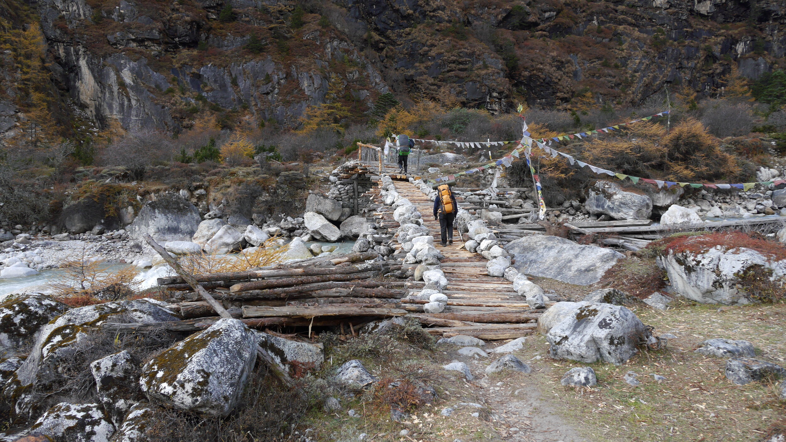
This morning, it was still a toss in Sangey’s mind whether Dawa would stay or go despite my insistence that he goes down. Finally, we paid him and he went down. He crossed the bridge and disappeared into the green hills below.

We went the opposite way at 7am and immediately ascended 700m from the village. Then down a little and up another 1,000m. The total elevation gain in a short time was 1,800m to a kharka and a simple teahouse at 3,350m. During the last two hours of our ascent it started to rain again. The walking in the rain and clouds is getting old. This evening though, there was no rain so hopefully the weather will change.
At lunch we stopped at an animal shelter that was also a camp for an old man and his grandson. It was one of the filthiest spots that I have ever seen humans living in. On one side of the shelter, a stable for the cows. The cows standing and lying in their own shit as cows tend to do. Right next to it, on the other side of the small shelter, the old man’s bed, fire and food scattered all around. We were invited in and it was difficult to find a shit free spot to sit in. The stench was oppressive. Sangey had some water left over form making butter, which gave him stomach problems later. The offer of a lunch or any food in this place was a non-starter for me. The man was very nice and sold us some milk and tea. What a spot though…

Once we got to the teahouse at 3,350m, we needed to sort out where I would sleep as we had no tent. This was not a standard teahouse but a large barn with a fireplace in the middle for the porters. Since we run into another group (camped outside in the mud and rain) the shelter was full of rowdy porters from that group drinking rakshi in a thick smoke from the fire stove. I had some of the rakshi as well and it was actually quite good, sweet in taste and smooth. The large group camping outside was from the Canadian Himalayan Holidays. They looked rather miserable camped in the rain in the mud in wet tents. Everything was soaked as they camped in the rain we had during the last few days and did not have a chance to dry off. It was nice to speak with someone in full sentences.

I ended up sleeping in the only room that belonged to the teahouse keeper. He was kind enough to rent it out to me for the night. The main hall of the shelter had around 40 men piled into it. In the evening the porters were making quite a racket. The night was loud with snoring, harking, talking. Tomorrow, we apparently have a long day with a 900m ascent.

October 18, 2013 Tseram 3,850m
The day started disappointingly in the fog and rain again. We walked at the top of the nearby ridge half of which was taken down in a huge landslide. It was cool to watch the porters disappear into the fog like the opening scene from Herzog’s Aguirre. We walked in pissing rain for 3 hours to Toronton. The trail was slippery on numerous roots and rocks. We had a short break in Toronton where I run into the Canadians again. I asked them how did they fare on this tricky terrain, as they were older than me by 20 years on average. The answer to this was: with strong painkillers, knee braces and numerous other pills they carry with them. They did not look like they were having a good time.

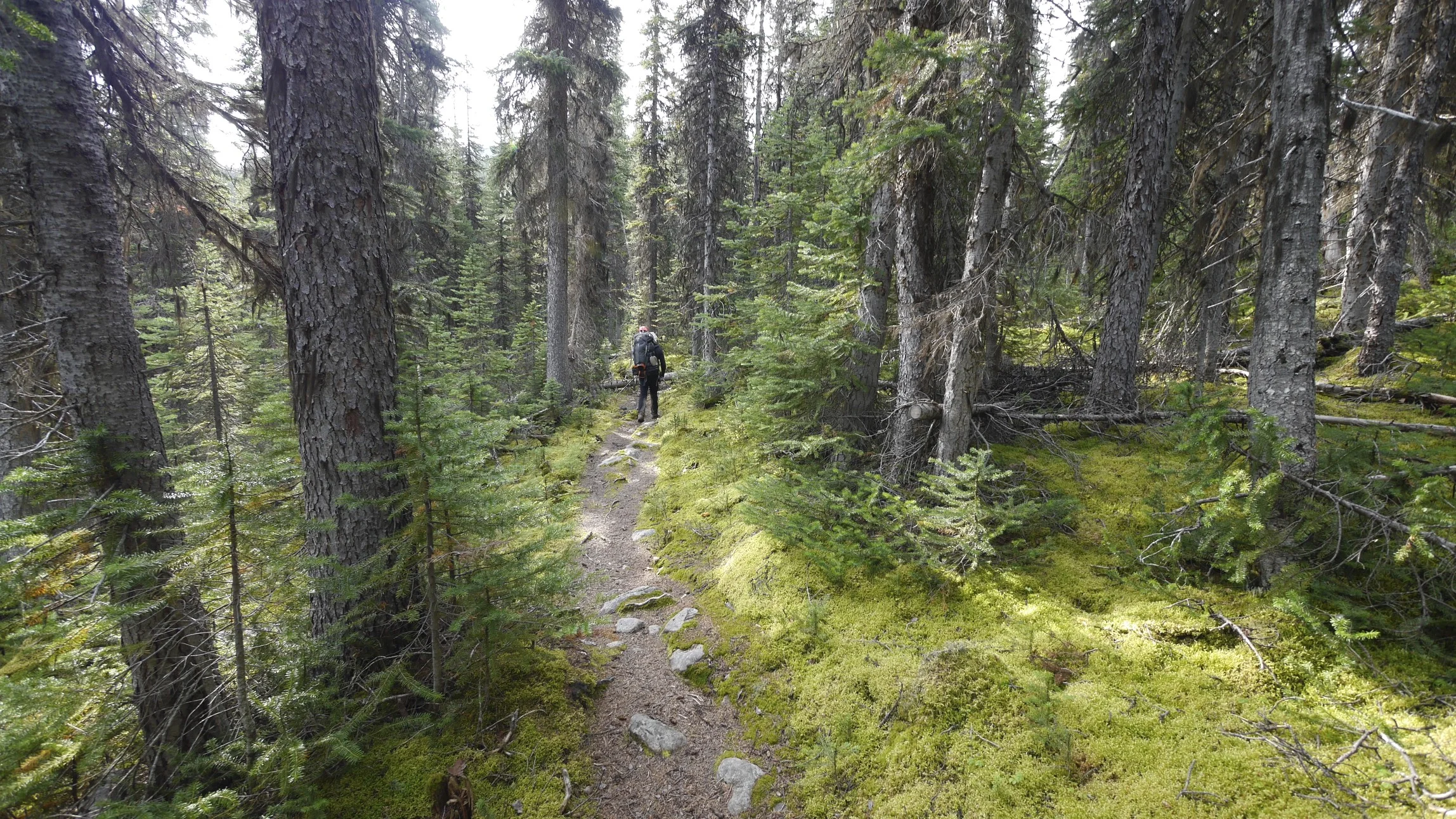
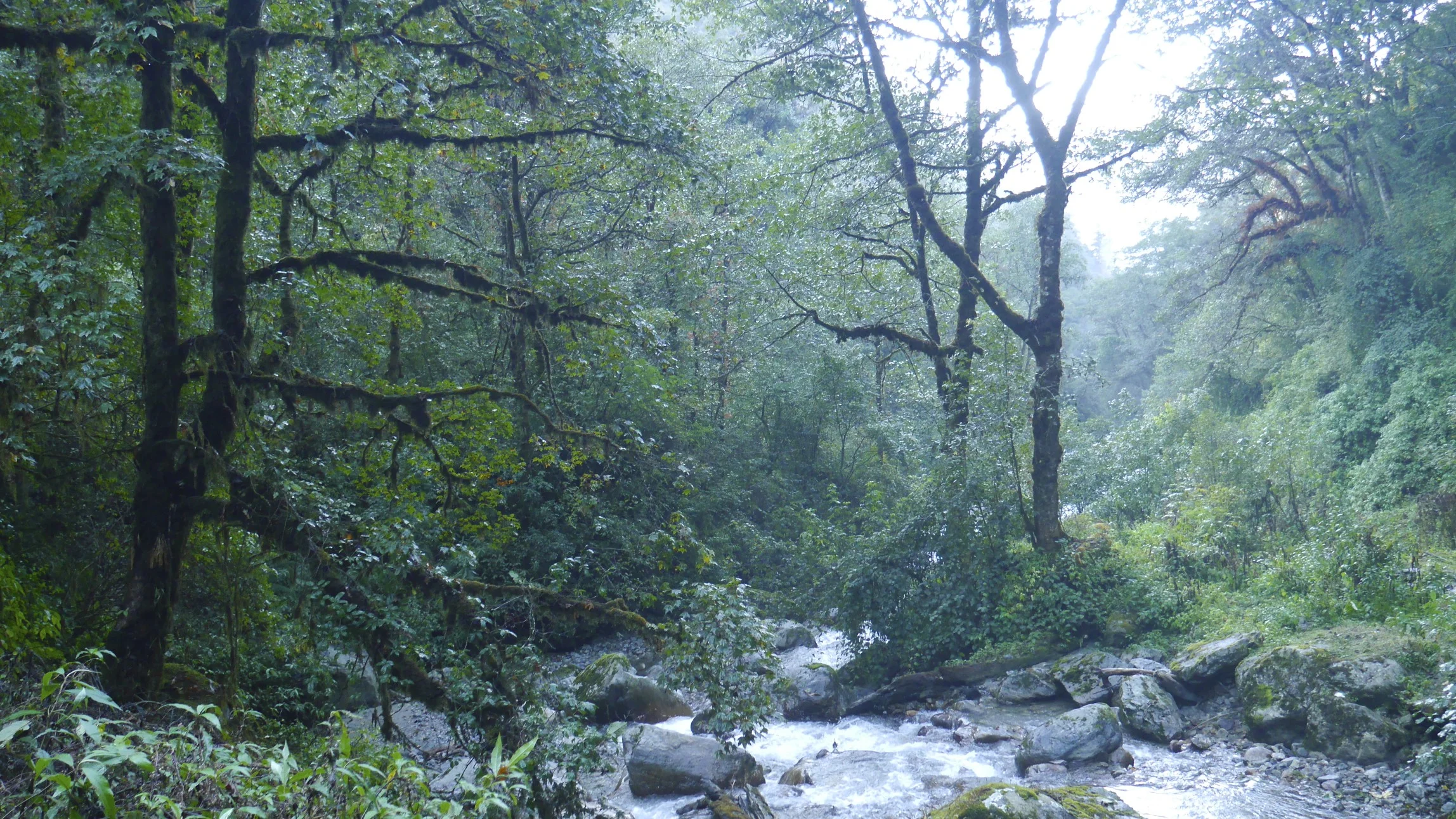
From Toronton we walked for another 4 hours along the river flowing from the South Kanchenjunga Glacier. The walk was through a really old majestic forest with huge pine trees. The river banks were steep and rugged, battered by water runoffs, that were no doubt, very violent when they happened. It rained all the way with mist and clouds milling around. I would lie if I said that it was magical as at the time it was frankly shitty. I was thinking how done I was with these forest walks in pissing rain for days. We were clearing the tree line and getting into the alpine so my hope was that the aura would improve. So far, this experience has been about rain, clouds, leeches, mud, dirt and thick forests. This reminded my of the trek we did few years back in the western part of Nepal to Simikot. Today is October 18th so I hope that the odds are that from this point on the weather should improve.

The teahouse in Tseram was very nice but crowded. There were quite a few other trekkers there as it is the last major point before the Kanchenjunga South basecamp. The elevation gain today was 800m and the distance between 12-14 km.
October 19, 2013 3,830 Tseram
Again the rain was pissing all night long. The shelter was loud and full of people, as they would rather sleep anywhere but in the wet tents in this incessant rain. In the evening the shelter got very loud. The “room” was really a big box nailed together from sheets of plywood. Lying in my sleeping bag, a mouse run across it and straight to the slab of cheese that Sangey left out on top of the bag. Since the mice were feasting on it, the cheese had to be thrown out. The shelter patrons were very loud and ill mannered (if I can even use this term in this context). They hork, slurp, burp, fart and behave very loudly. All of the preceding bodily noises increased in intensity with the amount of alcohol consumed. We were stuck here for the time being due to the rain. At least we had the luxury of time to wait it out. Among the captors in the teahouse was a lovely couple from Belgium. Their goal is to attempt the Kanch section of the Great Himalaya Trail. We had a great talk about travels and many other things. Then a nice guy Peter from BC, Canada joined us. He was very knowledgeable about digital photography. All in all the rain day went by nicely in good company with many momos consumed.
As I was sitting out the rain, I thought that this would be my last trip to Nepal. The charm has worn off and I was starting to focus on the negative aspects of the experience. This felt wrong somehow. I thought that, in order to get to the alpine, which was the objective and the reason for coming here, one had to navigate long, deep river valleys for days. Passing through the villages seemed no longer interesting for me.
October 20, 2013 Ramze 4,100, Oktang viewpoint 4,750m Kanchenjunga South basecamp
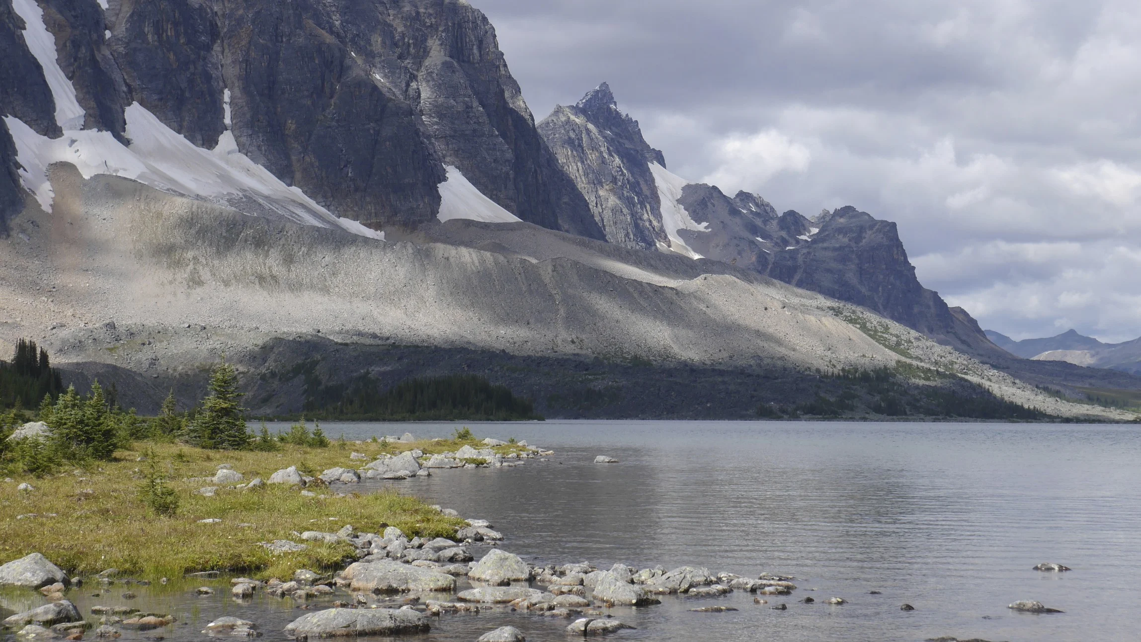
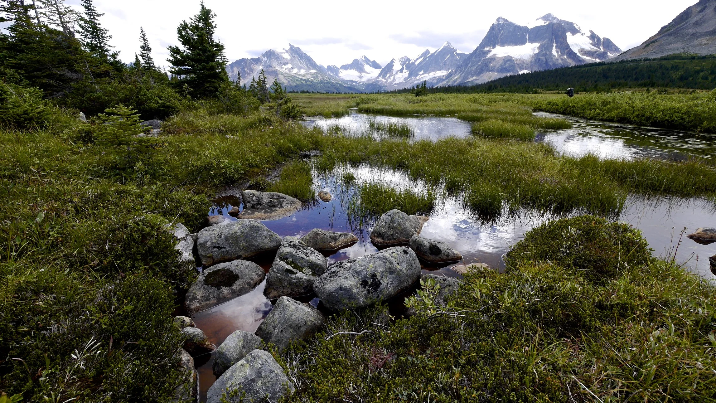
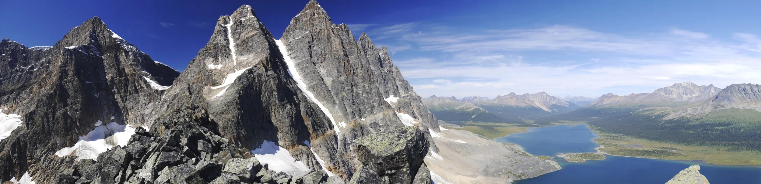
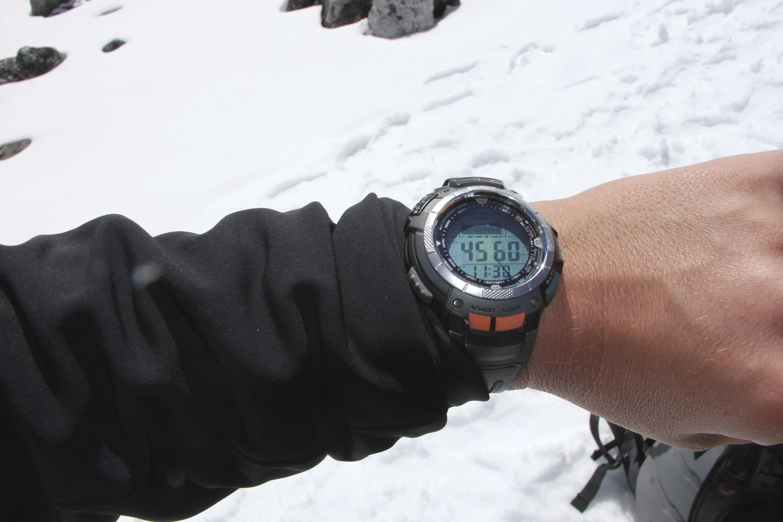
With the sun, my mood improved considerably! I am sitting outside in front of an incredible panorama of high mountains. We started early in the morning and went up to Ramze at 4,100m. Ramze is a name of a very nice stone shelter where, surprisingly, I was by myself.
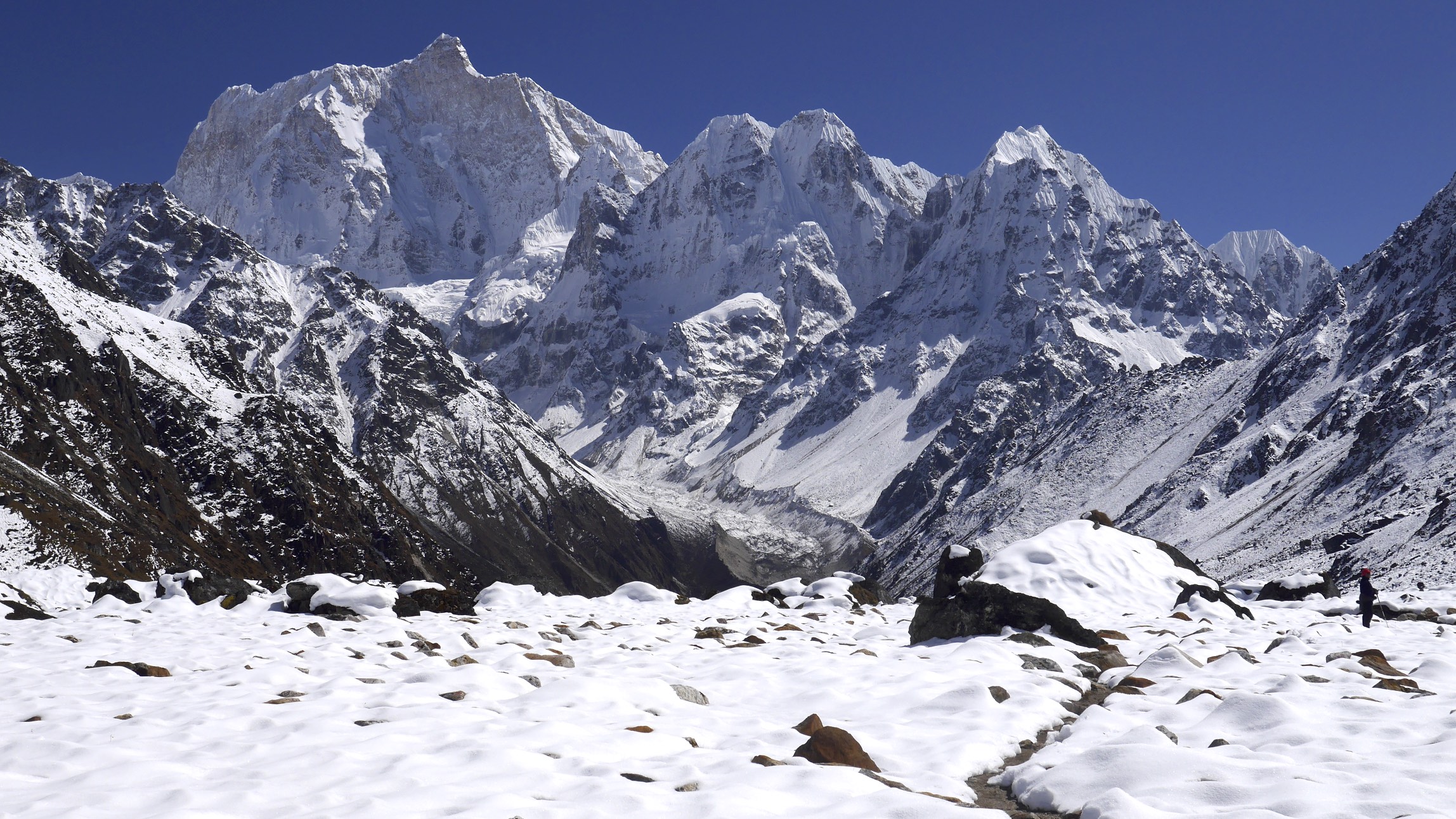
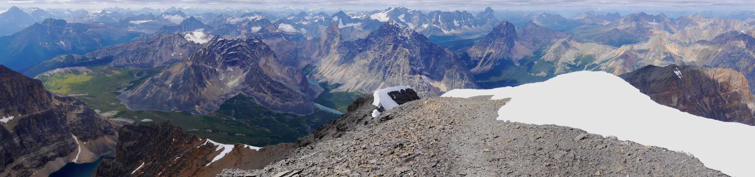
The day began, again, in a thick fog but soon after we left the teahouse in Tseram, the fog lifted and an outstanding panorama ahead was revealed. So on we went. Half way up, the fog and clouds reappeared but as we went higher the weather cleared up. After we reached the stone hut at Ramze (where we would spend the next two nights) we took a short break. In the afternoon, Sangey and I left for Oktang viewpoint to see the spectacular south side of Kanchenjunga along with Rotang and Kabru peaks. Although Kanchenjunga seemed like the king of the valley, it was far away at the end of the long Yalung glacier. Right in front of the Oktang viewpoint, where we were standing, was Rotang peak. The mountains around us were shrouded in white wispy clouds that were parting as we arrived. Due to the recent rain and snow the entire area was covered in fresh snow which added to the ambiance of the high mountains.

The Oktang viewpoint is situated on the crest of a moraine of the Yalung glacier. The Yalung Glacier flows from South Kanhendzonga, a short distance away. Getting to the basecamp proper requires a few hours of glacier walking on a route marked with large yellow poles. The Oktang viewpoint had many prayer flags and was surrounded by a wall of high peaks. Sangey performed a small puja with biscuits and chanting. I took many wonderful photos and it was time to walk back to Ramze. Oktang is an awesome spot. It was a shame though that it was such a wet slog to get here!
In the evening, the sunset was spectacular illuminating the peaks in all shades of orange. I had a private gallery to admire the wonderful views all around.

October 21, 2013 Ramze
The night was clear with a full moon. The silver light of the moon illuminated the peaks around us. I woke up on my birthday to a clear and sunny day. I called home on the sat phone and after had a great breakfast al fresco with the panorama of the Himalayan peaks right in front of me. I was here by myself again. What happened to all the people from the teahouse below? After the breakfast Sangey and I walked up 300m above the stone shelter for even a better view of the peaks and glaciers below. It took us about two hours and we were now close to the 5,000m mark. The Yalung glacier snaked its way down the valley. In front of us, a wall of peaks formed the border between Nepal and Sikkim in India. It was truly an awesome place and great way to spend my 43rd birthday.

As we walked, Sangey produced a thermos of hot tea at every turn. He is a very nice man and is trying so hard to be of assistance the best he can. After admiring the wonderful panorama for a while, we descended back to the stone hut of Ramze. As were were getting ready to leave, we met the Canadian group again and had a nice chat. We then went back to Tseram and after 2 hours we arrived in the same teahouse, which was much less crowded than two days before. Tomorrow we will cross Sera La Pass to take us to the north side of Kanjendzonga massif.
October 22, 2013 Sera La

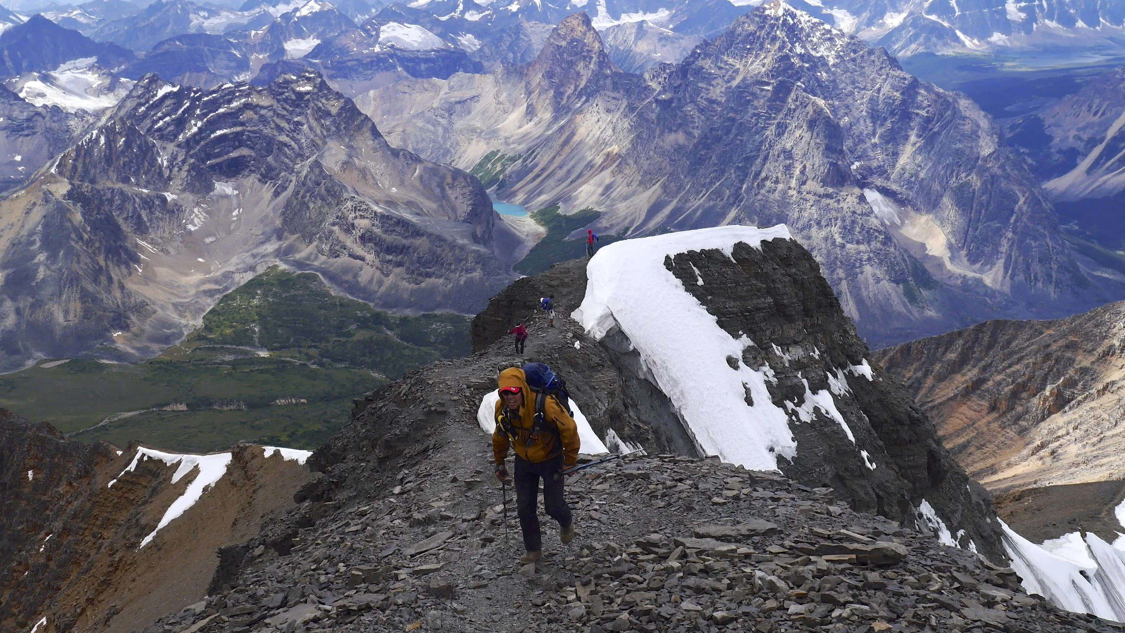
The climb to Sera La Pass was very spectacular. The trail started right behind the teahouse. We had a nice day again. As we ascended higher the views over the valley got even more spectacular. The view towards the Yalung Glacier was absolutely outstanding with a great panorama of peaks rising behind it. We arrived at the first pass (Sera La Pass consists of three distinct passes), took photos of the Kanchenjunga group and all the other peaks.

The Sera La Pass is not really one pass but a broad mountain that needs to be traversed to get to the north side of Kanchenjunga. We were concerned that we would not be able to find the way due to the recent snowfall as Sangey did not know the way and we were "winging it". Thankfully, there was someone there before us and the trail was already made. We arrived at the second pass with views extending in the westerly direction all the way to Makalu and Everest. I wanted to see this view very much as I probably saw the spot that we were standing on from the Shiphton Pass that we crossed on the way to Makalu in 2012. The weather gods were now smiling at us at last at the top of the pass. We had a good lunch with many servings of tea from Sangey’s thermos.


On the descend, around 11.45 – 12.00, the weather gods stopped smiling. The clouds moved in, it started snowing and the wind was now cold and strong. We arrived at the Selele high camp frozen. The Selele camp is high and cold. During the evening two Israelis gave us an awesome performance of Klesmer music on traditional instruments that they carried all the way here! The Nepalis enjoyed it very much as Daniel (one of the two guys) was a very skilled musician. Then it got too cold for music and we retired to our sleeping bags. At night it was freezing cold. I woke up at 3 am and could not sleep due to the cold.
October 23, 2013 Gunsa 3300m, Kangabchen 4,000m
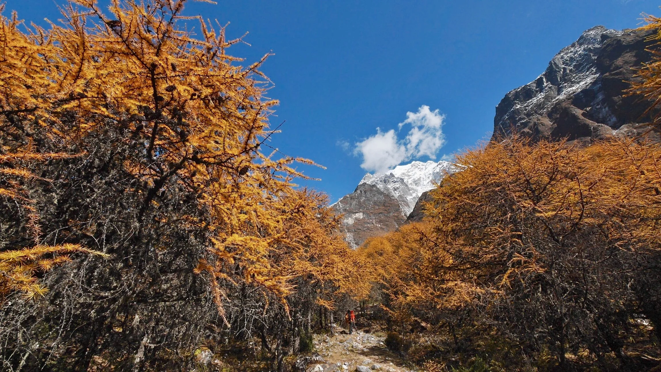
We got up at 5 am, mainly due to the cold temperature and had breakfast consisting of Tibetan bread and an oily omelet. We then started the descent to Gunsa which is the main village on the trek to the north side of Kanchenjunga. It was an uninspiring walk with nice views but nothing special. In Gunsa, the surroundings were different from the other valley. The fall was already here and the forest of golden trees surrounded us. Gunsa is a lovely village with many traditional houses. We had lunch in one such house belonging to a lovely Sherpa couple. After lunch, we made an arrangement to leave some of our gear behind, and proceeded to Kangbachen.
We also met a Turkish guy who escaped (literally) from the K BC in Pangpema. He got caught in the same storm that tormented us on the south side of the massif. Instead of rain, he experienced an epic snowfall that stranded him and his guide in Pangpema. They went there for a day hike and it started to snow heavily. The teahouse owner left but following the advice from his guide, the Turkish guy decided to wait out the storm. The storm lasted for a few days and produced snow drifts up to the roof line of the teahouse. The situation became quite desperate once the food supplies ran low and they tried to dig their way out. After 500m of digging they gave up and decided to make snowshoes from the wood planks of the teahouse walls. This way they crawled back to Lhonak over a two day struggle making it half way during the first day and all the way during the second day. An experience that shook him up and caused a major fallout between him and his guide.

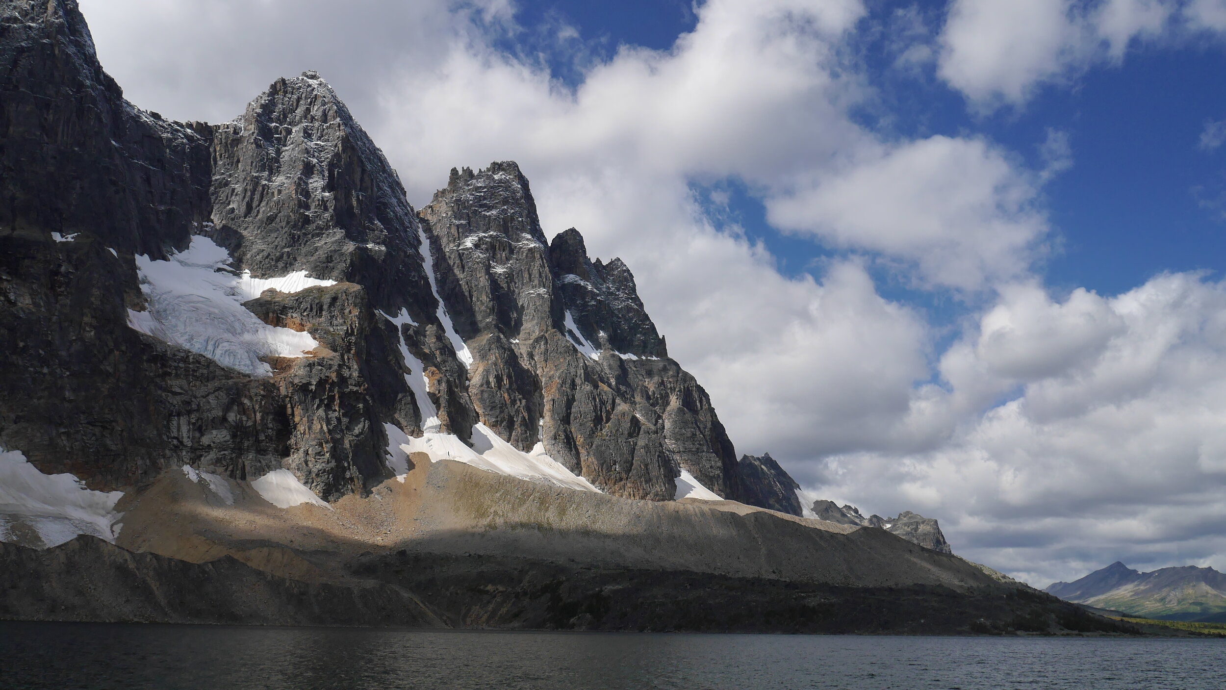
The walk to Kangbachen was great but long (10km). The sun was hot and we walked passed larches that were changing their colors from green to gold. It was a stark contrast to the jungle we passed just a few days before. After the valley walk, we crossed a river and walked up a glacial moraine of the Janu glacier. As we got higher the spectacular west side of Janu came into the view. It was vertical wall of rock illuminated by the late afternoon sun. Absolutely stunning. We crossed a tricky section of the trail traversing a recent landslide with many loose rocks. I would not want to be on this path in the rain.

It was getting late and the sun was setting when Kangbochen came into view. The settlement is spectacularly located at the entrance to the Janu Glacier. It consists of some simple stone huts and it is clean and tidy. The teahouse was also clean with white sheets! A first on any trail in Nepal. The owner of the teahouse has an expedition drum that belonged to the 1974 Polish Kangbachen team. A true artifact of mountaineering history. Tomorrow we will take a day off as we have been going non-stop for 10 days. I really need a good night sleep without the cold or the noisy Nepalese rising at 4.30 am. After a good night I will feel better for Pangpema and the North Basecamp of Kanchenjunga. It looks like the weather has stabilized.

October 24 and Oct 25, 2013 Kangbachen 4,000m
Today is the well-deserved rest day in Kangbachen. We decided to go for a walk and explore the valley above the settlement. As we walked up higher we got spectacular views of the entire Janu group. It was very hot in the sun, although we were walking in deep snow (the remains of the recent epic storm). Once the wind picked up though the cold was quite noticeable. We walked up quite high (perhaps up to 5,000m or more again) and it just got too tiring to walk up any higher. We spent the better part of the day exploring the valley above the camp.

Pangpema, the Kanchenjunga basecamp is 20 km away and we may try to get there in one day. The food in Kangbachen is mediocre at best. We spent $100 for the 3 of us here and I consider it very expensive compared to other places. The Sherpa woman that runs the teahouse here reminds me of the Khumbu business women. There is a girl in the kitchen that is working all the time form 5 am until the night. Sangey claims that she was the daughter of the owner but he was not clear about it and I would not rely on his interpretation. The Nepalese hiker we met said that she was a hired help from down below and judging by the way she was treated, I would agree.

Every teahouse has a kid my son's age (10). The kid works really hard, like a slave, from the morning until late evening. The work involves fetching water, chopping wood, cleaning, washing, cooking etc. By comparison, mo son has it so easy and he does not realize it. I wander why do these kids do not go to school? We passed a few schools and they were all empty.
October 25 Lhonak 4,700m
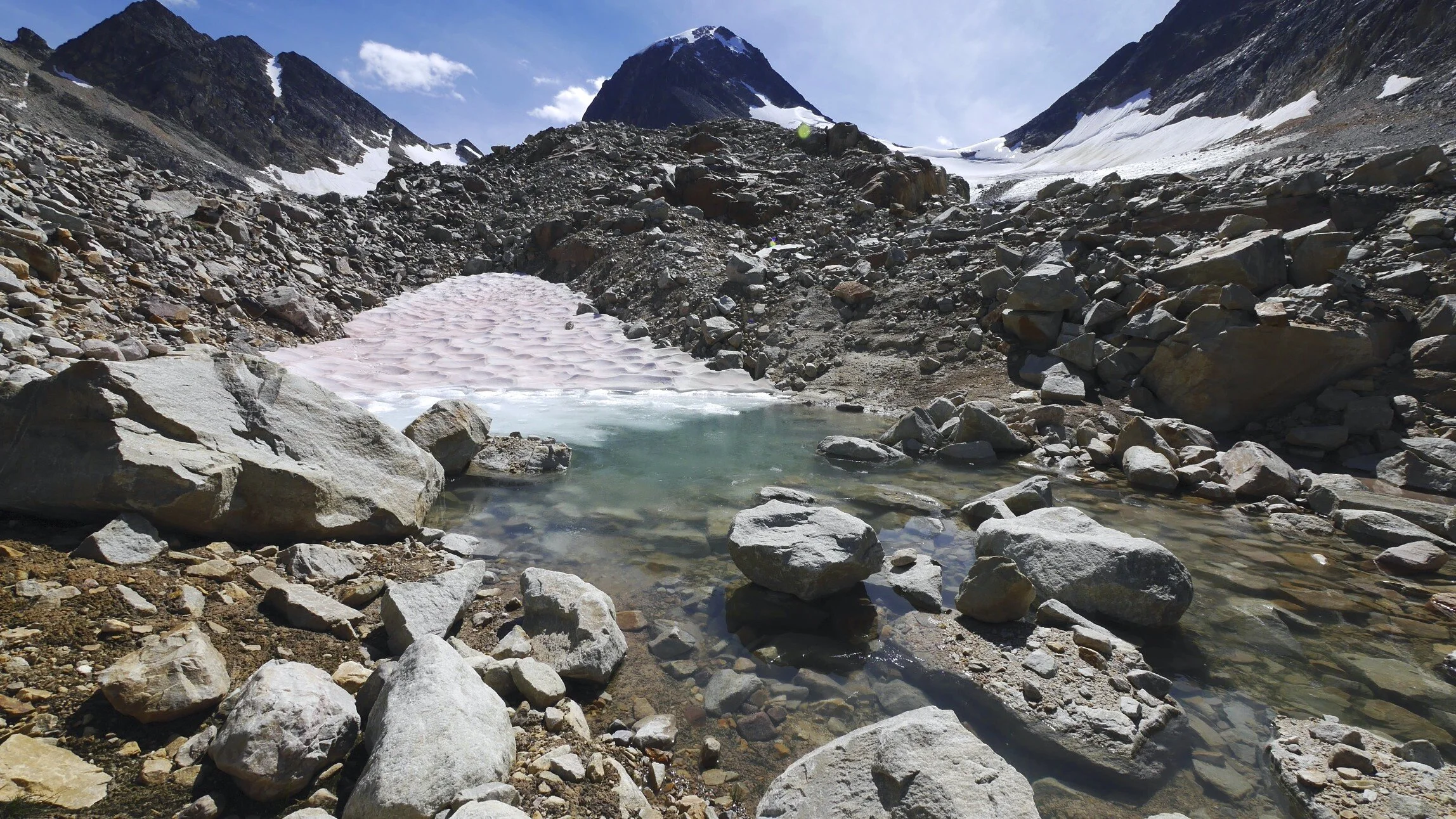
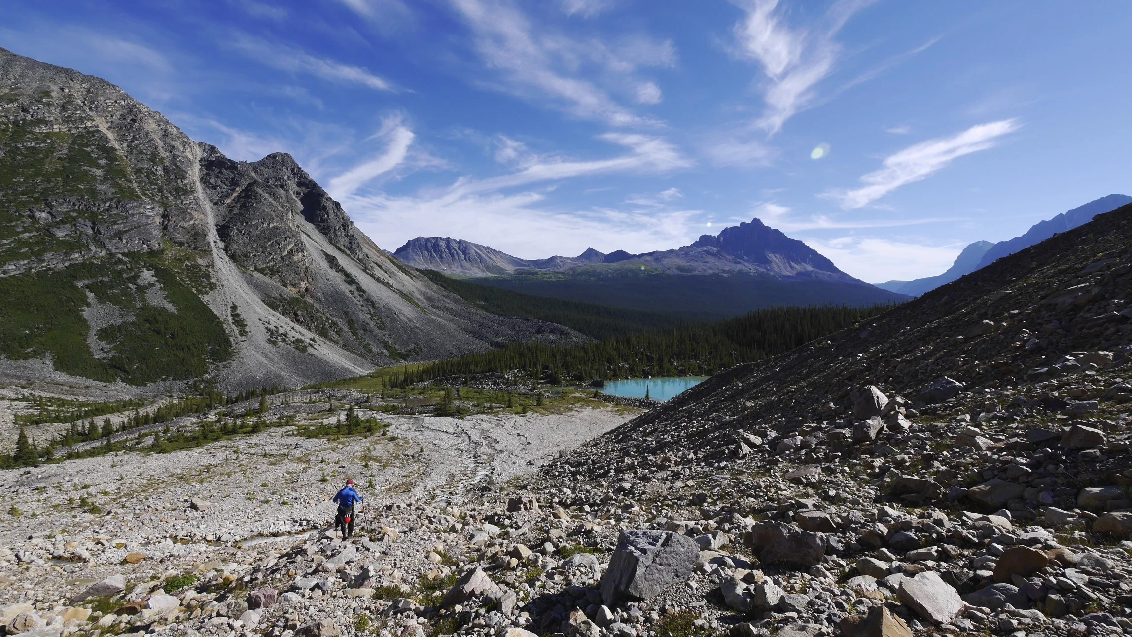
Today we walked up from Kangbachen to Lhonak, as apparently there is no room in Pangpema. We started the day early with the idea of walking all the way to Pangpema though. Walking above 4,500m again became hard.

I am not that well acclimatized as majority of this trek so far has been on lower terrain. We had to negotiate some tricky sections across boulder fields and loose moraines. We also walked across frozen rivers and by some spectacular waterfalls. The weather was spectacular and we had great views that were just getting better the higher we went. We met a nice Nepalese guy from Ilam who is walking with us. He was on his own but considering he is a local, it was understandable.


Lhonak is a lovely spot at the foot of a large mountain called Wedge Peak and behind the moraine of the glacier descending from the Kanchenjunga North side. As we approached Lhonak, in deep snow, the scenery was becoming truly alpine. High peaks, glaciers, high above the tree line by now. It is funny, but I felt ambivalent about going to Pangpema (although I was very happy to have gone there).
Sangey’s English was frustrating me. He is a really good guy and always there for me with a hot cup of tea from the thermos that he keeps inside his coat. He tries hard. However, there is no way of communicating with him about things that are more complicated than asking for one more cup of tea. I do appreciate his assistance though and as a facilitator he does well. I think given my relationship with Kumar, it is disappointing not being able to get to know the guy a little better and develop a deeper relationship with the guide. Especially that we spend so much time together.
The prices on the north side of Kanchenjunga are much higher than on the south side. It is a really long way to come to spend some time in the Himalayan wilderness. One has to walk 6 days in the dirt and chaos of the Nepalese lowlands to get to the alpine.

The night in the hut in Lhonak was very cold and it was very cold in the morning too. My boots were a block of ice. My soft boots are quite useless for these conditions (wet and cold). Tomorrow I will try to sleep in the kitchen regardless of the noise from the many porters that sleep there as well.
October 26, 2013 Lhonak 4,750m
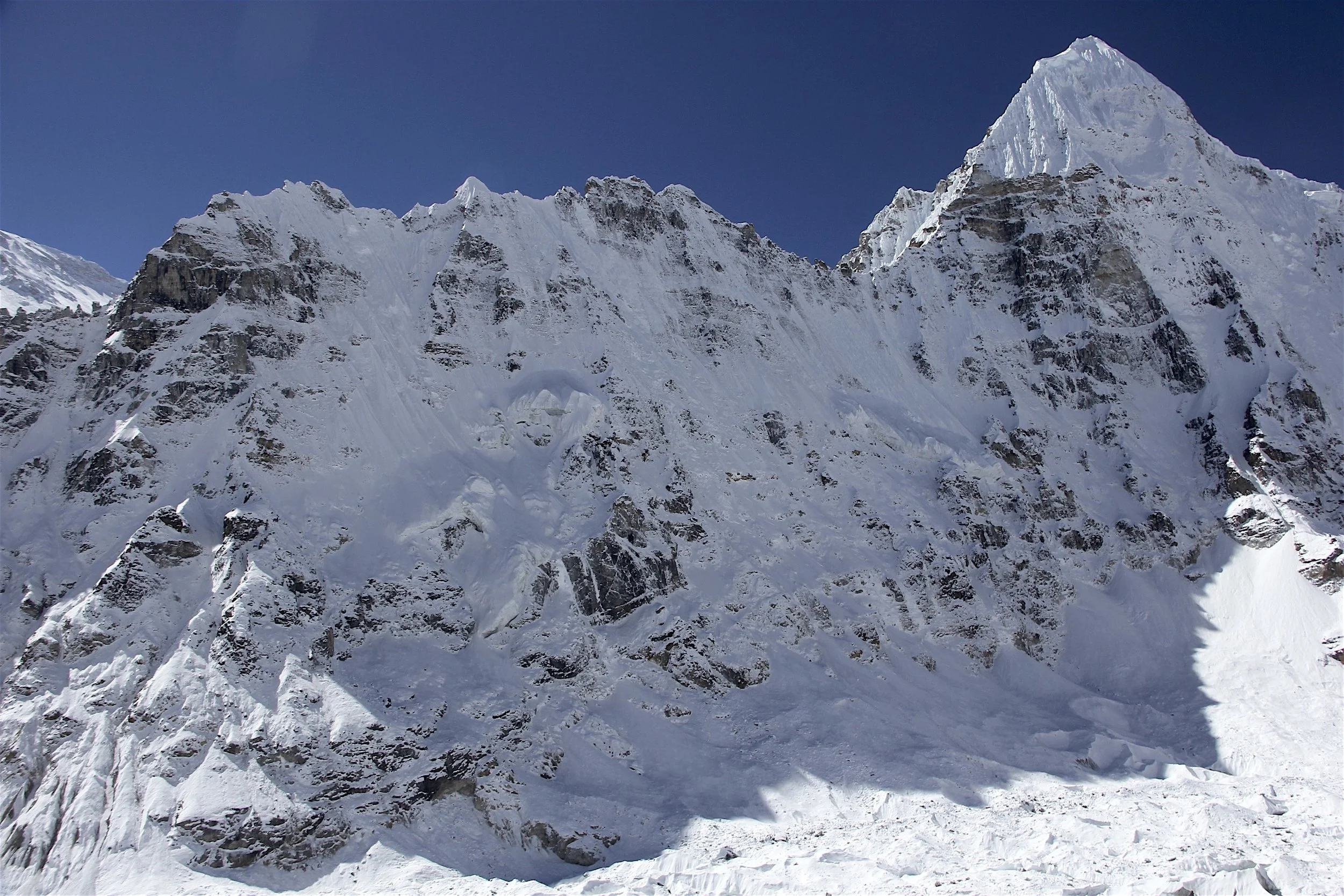
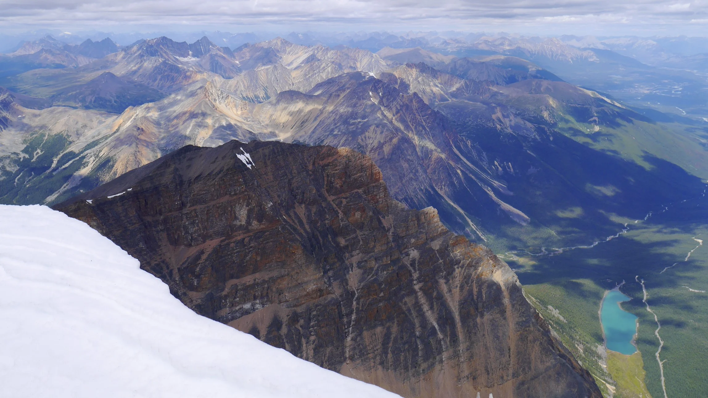
From Lhonak we went to Pangpema for a day hike. We started at 6.30 am anticipating a long day ahead. It took 3.5 hours to get to Pangpema and in retrospect we should have stayed there are the teahouse was empty. The location of the teahouse was spectacular overlooking the entire north face of Kanchenjunga. I climbed up another 150 - 200m on a hill behind the teahouse. I wanted to go to the top of it but the snow was too deep. The north face of Kanchenjunga is huge.

On the photos it looks small and distant but in reality it is right in front of you. It looks like a very formidable and difficult peak to scale from this side. It is after all the third highest peak on Earth after Everest and K2. I was thinking of Wanda Rutkiewicz who disappeared on the slopes of this mountain without a trace. I am very happy to be here and to have an opportunity to see it.

Above Gunsa, this trek is great with fantastic views. It reminds me a little of Pakistan. Kanchenjunga is as remote as K2 in Pakistan. It is just a long way from the road. On the way back from Pangpema to Lhonak we witnessed a huge avalanche from the peak across the glacier from where we were sitting. The snow dust from the avalanche traveled across the glacier and engulfed us in no time. This is a very dramatic landscape. My boots are completely wet and I hope that I can dry them by the fire tonight.

We returned to Lhonak in late afternoon. By the evening, the weather was clear and I admired the spectacular sunset from the top of the moraine overlooking the glacier. The light was fantastic and the view was grand. Silence, with towering peaks all around changing colors in the setting sun. I spent the night in the kitchen, which was packed with porters sleeping everywhere. The space next to ours was occupied by another group of porters and their kitchen. The porters were up by 3.30 am making a lot of noise. There is no regard for privacy here and no consideration for another. Most of the porters smell of alcohol while walking on the trail first thing in the morning. The Lhonak lodge is very remote and I am grateful of the warm place to sleep no matter how gross it is.
Sangey bought some meat for dinner from the teahouse lady. The slab of freshly butchered yak was hanging off the rafters in the kitchen. It is freezing here so the meat really hangs in the natural cooler. The Canadian group arrived today as well. Only 6 of the 12 participants made it here. The other members just could not make it and went back. The gathered porters started drinking and smoking. They start their day with a drink (maybe for warmth?). By 5 pm they are already half gunned and one can smell alcohol on many of them. Since some of them are still kids, it is really sad to see.

Today I also met a Japanese fellow who is 81 years old. In contrast to all the people I meet I do not feel so tough. I met so many people who seem to do so much. The locals, of course, are tough like oxen. I seem to enjoy and do different kind of trekking from the others, with more focus on the alpine.
October 27, 2013 Ghunsa 3,450m
We said goodbye to the beautiful setting of Lhonak and walked down to Ghunsa. The weather was great; we quickly descended to Kangbachen through the boulder fields and moraines. In Kangabchen, I bought a carpet from the owner of the lodge for 8,000 RS (original asking price was 15,000) where we stayed on the way up. I also photographed the Polish Kangbechen drum. After a good lunch by the river we arrived in Ghunsa (20km).


We are staying in the Snow Leopard hotel with Dalai Lama looking over me with his angelic smile from the photo above the bed as I sleep. I had a warm bucket shower and is feels great to be clean. I am starting to look forward to the end.
In Ghunsa I went to see an interesting Nepalese guy who mans a collection of remote cameras in the mountains above the village. The cameras are used for research of the Himalayan snow leopard. One of his cameras caught a black panther that has never been seen at these altitudes. It was very interesting.
October 28th Gyabla 2,750m

We started our descent in the frosty morning in beautiful clear weather. A light dusting of snow on hills and peaks all around us signaled the coming winter.

We had a lovely walk by the river down to a Tibetan village famous for carpet production. We conducted some more carpet business with the locals. It turned out that the price I paid to the lady in Kangbechen was about right.

The trail then descended quite steeply into the jungle. The trail was up and down all day like a rollercoaster. I am quite tired now and the day today just tired me out even further. The final push to Gyabla was a big climb and a big descent to the river and then another big climb again. When we go there, the owner of the teashop and his son started killing a large hog. It was a total pandemonium as the local people wanted to kill it with a bamboo stake pushed through the pig’s heart and not with the knife. In their opinion, the knife was not pure or traditional enough. Since they could not poke the pig properly as it was fighting back and it was huge, the animal suffered a lot. The pig did not want to die and the villagers just kept injuring it further. It was like a bullfight with a lot of blood and grandstanding. The ego and pride was now more important than anything. It was all insane and very cruel.


These people were very rough and did not seem to have any sensitivity or compassion towards the animal regardless of their religious believes. Once the hog was finally killed, after an hour of struggling in the rain and mud, they set the animal on fire to burn off the hair. They then cleaned it with cups and butchered it quite efficiently. I was offered the final product later but I could not even look at it.
Everything on me stinks like a wet dog. I cannot wash anything, as it will not dry as it rains every day again. Today it rained and snowed for 6 hours. Yesterday it rained all night and snowed higher up. The snow is literally chasing us down the valley. It is now cold and damp at 2,700m. Usually at this elevation is already hot and humid. Apparently, it is an unusual fall in Nepal this year.
October 29, 2013 Sukethum 1750m
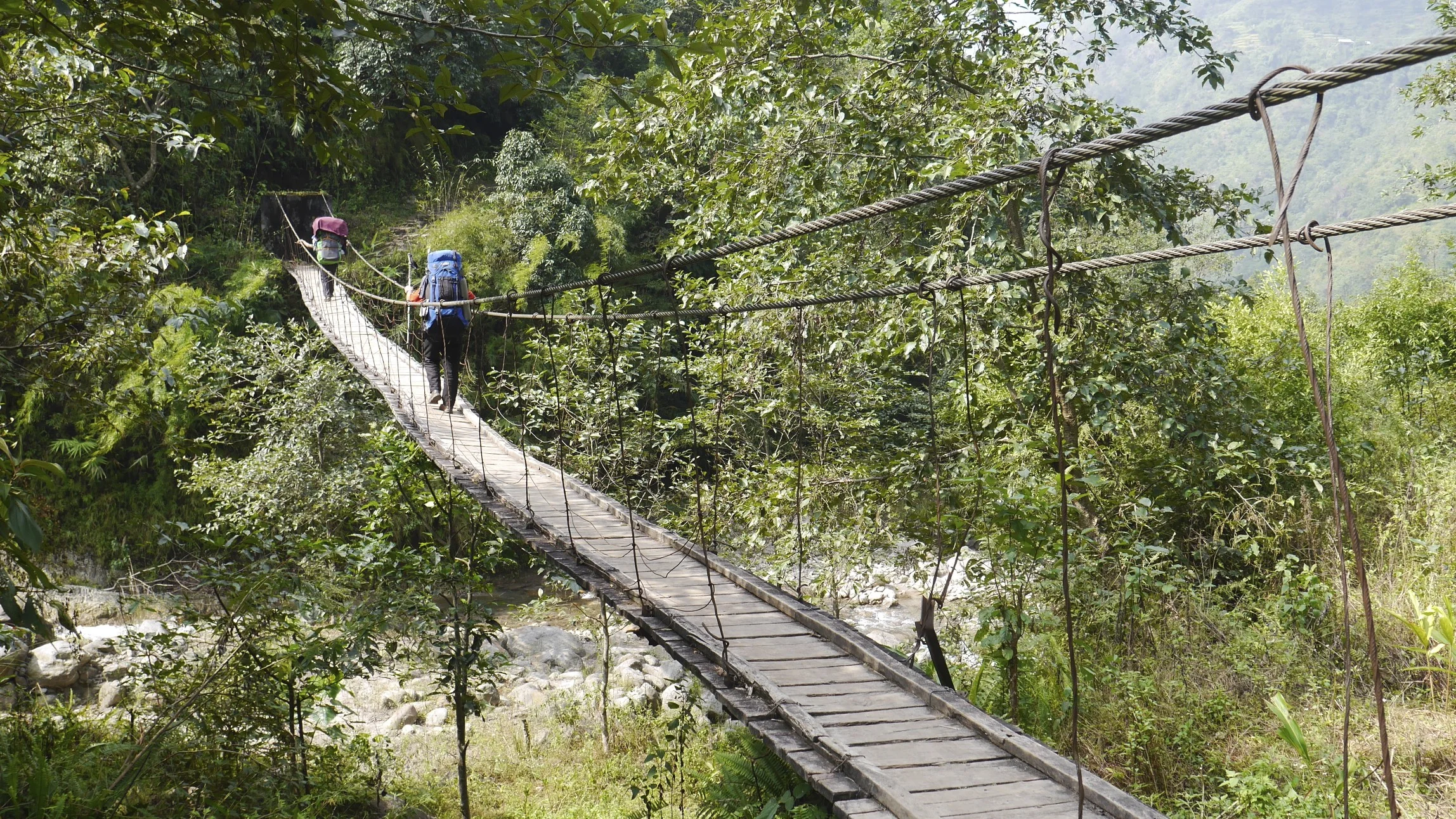
Today we walked in the gorge of the Tamor River. It was spectacular. The nature was explosive all around us with vivid colors and abundant waterfalls of various shapes and sizes. At one point, the trail went right by the river. The trail was built from wooden planks and reinforced by rocks with the raging river flowing right under my feet. The waterfalls were awesome; some of them were 100-200 m tall. This was the most spectacular valley and the river walk I have seen in Nepal so far. I have to admit that Kanchenjunga is one of the most beautiful treks in Nepal.

Yes, the villages and the homes and teahouses are very basic but I will have to say that they are authentic. This is just how the life is here in these remote parts. The nature, the views, and the mountains are some of the most beautiful in Nepal. The region is undeveloped and not trampled by mass tourism like Everest or Annapurna regions. The trek is tough and very long and the walking is difficult.
The trail by the Tamor River went up and down like a rollercoaster for 7 hours. It climbs for 50 m and it drops for 50 m all day long, there are no flat sections. The views of the gorge made up for it, as it was truly spectacular.

We got to the village and the owner of the guesthouse was not to keen to take us in. He sent us up the hill to another place. When we got there, its owner was also not very keen to take us in and offered a cold reception. Sangey was persistent though (we were all tired) and we were allowed to stay.

Wen we were waiting for food I was observing the comings and goings in the kitchen. Everything is done on the floor. Why would they not build a table? They squat and do everything this way. For me, being so tall, it is very uncomfortable. In this guesthouse, the owner, a father of 12 children, is sitting on the floor double fisting the tumba (a local beer like drink served in large wooden tumblers). The locals start drinking tumba at 6 am and go all day, mildly buzzed. The fellow is watching his wife and daughter without lending a hand. I guess, the division of labor is very clearly defined and the kitchen is no place for a man to be involved. This is a remote part of Nepal and it is an interesting to experience how real Nepalese live. I think that it would be very difficult to change these people as the habits are so deeply ingrained and the behaviors are universal among them.

October 30, 2013 Sinwa 1,075m
Today was another fantastic day. What a difference nice weather makes. We started at 7 am from Suketum and went down again. We got lost initially as the trail branches off in different directions. We passed Chirwa where we had great lunch of chow main, bamboo pickle and fresh fruit (guava, lemons and oranges). We walked through farms with abundant crops. The lower we got the lusher the forest until it became a thick jungle. On the way, we saw a dead body being carried by the locals for burial. The person died in the clinic in Tapeljung and had to be carried back home for burial. The locals carried the wooden box on a bamboo frame on a very tricky trail. I guess this is the way they would evacuate someone in case of an injury.


We then walked through some thick forest to the village of Sinwa. Sinwa is a typical Nepalese small town. We lodged in a dingy dark hotel. The room was a plywood cell the size of a bed with walls covered in newspapers for charm and atmosphere. It filled up with smoke from the kitchen below, as the stove is not properly ventilated to the outside. This is one of the reasons why everyone coughs here all the time. They must suffer from respiratory afflictions after breathing the smoke from an early age.
Kamsing bought a scrawny chicken and we killed it right away to avoid the meat being tough. After the pig experience a few days before, killing of a chicken does not seem like a big deal. Tomorrow is Tapeljung and an official end to this grand adventure. It was tough and I was upset with the weather many times but overall it was also wild and spectacular. I think this was one of the most beautiful and varied treks in Nepal and honestly, I did enjoy being on my own again. I think that many people would quit especially after the first week of rain. By being alone, I was fortunate to meet many interesting people: Xavier, Marten, Daniel. They are all great and nice people.


October 31, 2013 Tapeljung 1835m
This is it! We covered 250km in record time (less than 20 days). This was my last day on the trek. The walk was not so good on a half finished road with a 900m climb from 920m to 1835m in the heat and humidity. I was feeling very strong however and we made the distance in record time. In Tepeljung we stopped for lunch and arranged a hotel where I met Marten form Belgium (we met in Tseram and Lhonak). I insisted that Sangey and Kamsing share the room with me, as they could not find accommodations. We both went to get a first class haircut and a massage for $1.20 and run into Xavier from Spain who I met in Pangpema. He told us that in Gunsa, after we left, there was a lot of snow and higher up even more snow. His plans for crossing to Olangchungnkola will have to wait for another time.

November 1 and 2, 2013 Ilam 1370
After a restless night due to Kamsing’s snoring and a Nepalese family hosting a reunion at 4am on the staircase of the hotel we got up at 4.45 am to catch a local bus to Ilam. The bus station a far away on the edge of town. We got there around 5.30am. The place had trash all over the place. The rickety bus left at 6 am and after 7 hours of crawling through the hills it dropped us off in Ilam at 12.30 pm. We walked uphill to the Chiyabati Cottage, a nice clean place located among the fields. I hope that the thick clouds life so that we can see the view.


The following morning I went to look at the tea plantations. Tea plants grow on all the hills surrounding Ilam. The tea growing extends into Sikkim in India. The region reminds me of Uganda. I really liked the green rolling hills with perfectly manicured tea plats like a forest of Japanese bonsai trees. In the middle of the tea plantations, a 100-year-old factory processes the harvest using traditional methods and antiquated equipment. I purchased a few bags of tea for gifts. Illam is a nice small town, very quiet and contained. I visited the Nepalese fellow I met on the trail from Kangbachen. He invited me to his house for tea where I met his family. His family runs a clothing store on the main street of Ilam and they live above it. Very nice and kind people.

November 4, 2013 Kathmandu
Last night at the Chibati Cottage, I wanted to be fancy and ordered a pizza for dinner. It turned out to be big mistake as it made me violently ill. I had terrible stomach cramps that culminated with me spending a lot of time on the toilet. We changed the tickets to Kathmandu for an earlier flight that allowed me to get into a clean hotel and a functioning toilet.
It is amazing how clean and organized Kathmandu seems after spending time in the Kanchendzonga area. When I arrived in Kathmandu three weeks prior, it all looked chaotic.
The trek was beautiful but also hard and tiring (perhaps also due to our pace – 19 days for 250km). Last night in Kathmandu there was a festival taking place and Thamel was hopping. Kathmandu is really a great city: vibrant and alive and there is nothing else like it. It definitely has a positive and a negative side to it. I am grateful to have head this experience and thankful that I did not get sick along the way. And yes, I will return…