


Participants: David, Gilles for Dhaulagiri with Siam the guide and his brothers as crew.
October 12, 2017
Sitting here at the airport in Calgary. It is hard to depart as it always is. The departure is definitely the least pleasant part of the trip. It is not getting easier for anyone including me. I was very busy at work right up to my departure.
October 13, 14, 15 2017 Calgary – Kathmandu
The flight from London to Doha was very nice. Only 6.5 hours. I could not sleep. We flew over the Zagros Mountains of Iran. It is great to see the green waters of the Gulf again. The Gulf always feels very exotic to me.
The flight from London landed in the new airport in Doha. The new airport is very impressive. It is huge and very modern. Since I had business class seats on the Qatar Airways flight to Kathmandu, I could use the business class facilities at the airport. The experience starts with a separate check in; very posh. The passport control is also separate for the business class passengers, no lineups, no hassle. I spent my time in the business class lounge where I had a shower, a good lunch, and a snooze. It was a great experience and very convenient after two intercontinental flights. The upgrade was very much worth it for the access to the facilities alone. After six hours at the airport I boarded the flight to Kathmandu. The reclining seats, good food and excellent service made it a very nice experience. Four hours later we landed in Kathmandu where Rajendra was waiting for me at 8 pm. Since I was in the business class I was out of the plane right away, taken to the empty arrivals hall where I moved through the visa formalities in warp speed.
So here I am again in Kathmandu after a three year break from my last trek. A lot has happened during this time. One year after my last trip, there was a huge earthquake that devastated Nepal and Kathmandu. The remnants of the disaster were visible right away. Cracked and destroyed buildings, piles of rubble on the streets, dust everywhere. Kathmandu got hammered and did not yet recover. We arrived at the Nirvana Garden Hotel after 9 pm. The hotel did not change much. The same guys were working there as three years ago. Everything in Thamel, the tourist district, was closed. I met with David and Gilles, we paid Rajendra for the trip, had a coke and called it the day. I had to repack as we left a few things behind in the hotel. We would leave first thing the next day for a two- day drive to the trailhead.
October 15, 2017

I got up at 5 am and went for a walk to the Dubar Square. I wanted to see the devastation from the earthquake. The street leading from the Nirvana Garden Hotel was very dusty with piles of rubble allover as if the earthquake happened last month. It looked like war-torn Aleppo. The Dubar Square was devastated and I was shocked to see it. The beautiful Newari temples are gone, all gone. Only the brick platforms remain and piles of rubble exposed to the elements with beautiful old wooden carvings just rotting away. The few buildings left standing were cracked, propped by wooded posts and in a bad shape. The entire scene was very sad to see. It all feels as if no effort was made to rebuild anything and the recovery is many decades away. It was all very sad and heart breaking. The place was still full of the locals selling produce first thing in the morning. Despite the devastation that took Kathmandu a few decades back, the spirit lives on.

I walked back to the hotel through dusty streets and had breakfast. After a quick breakfast, we met with Siam, piled into a jeep and departed for Pokhara. I did not have any time to do anything in Kathmandu. We drove for five hours to Pokhara on a dusty and crowded “National Highway”. From Pokhara we proceeded to Tatopani. We wanted to reach the trailhead in one day but once it got dark, the 4x4 only road became too treacherous to negotiate for the driver. We could not see the read very well as it was all up and down with numerous blind spots. Once we reached Tatopani, we decided to spent the night in a small but nice Himalaya Guesthouse and resume our drive the following day. We were all tired after 12 hours in the jeep.
October 17, 2017 Darban 800m
We got up at 6 am and resumed our jeep ride. The low hills of Nepal were green and vibrant. The sun rose from behind the hills illuminating the rice fields and the banana trees in a brilliant light. We had great views along the river in a deep gorge all the way to Darban. We got to our destination after one hour. We met with the rest of the crew who arrived there the day before on a bus from Kathmandu with all the gear. This is a camping trek and we need to bring everything with us. Dhaulagiri is considered as one of the most difficult treks in Nepal as it ventures into a wild and remote area. It also crosses some high passes with no easy escape route from them. We had a good breakfast in a local soccer field while the crew sorted out the loads for the porters. The weather was hot and sunny. I am finally getting excited about being here and I am eager to start the walk. The company is great, David of course and Gilles who is a very positive always smiling fellow from Montreal that we met on the K2 trip in 2016. We could see some tall snow covered mountains behind the ridge. The Himalayas were calling us again!
We started walking on a jeep road that was blocked by a big landslide. It was a very short day – only 2.5 hours. Before we really warmed up, we had to stop. The campsite was beside a small wooden bridge spanning a small river. As it was very hot and humid, we took a refreshing dip in that river as the locals were doing. We hung out for the rest of the day.
In the evening, although tired from the jetlag, we committed to watching the local performance of song and dance. The locals sang the same tune 50 times, shook their bodies (dancing?), and hit us up for a generous donation (for a school) at the end. The whole thing was a well-honed shakedown for cash. But since we agreed, we had to oblige. David and Gilles danced with the locals and did a valiant job. I just watched them dance, as the tunes were not grabbing me. We went to bed quite tired.
October 18, 2017 Passed Muri 1,540m 18 km from the trailhead
The Dhaulagiri trail is not very touristy. We have not seen any Westerners all day. We got up before 6 am and started walking at 7:30 am. It takes a little longer to get going, as we need to pack up the entire camp that includes the kitchen tent and the toilet tent! (I never had this luxury before). We started with a lot of enthusiasm and got ahead of our guide and porters. We took a wrong turn somewhere among the many variations of the main trail, asked the locals for directions (confirmed by the husband and negated by the wife), then made our own educated guess and went on. The trail climbed up to a wonderful pass with fantastic panorama of the high mountains ahead including Dhaulagiri. At the foot of the massive peaks were many villages and terraced rice fields in a kaleidoscopic mix of yellows and greens. We sat and admired the panorama for a while, met some locals and took photos. On the way down from the pass we stopped at a house of a local teacher (he told us that his school has 1,200 kids) and had a nice cold beer. His family has two really beautiful sisters one of which wants to become a commercial pilot (although she has never been in an airplane).

We continued our descent from the pass through rice fields and by now were clearly lost. We assumed that the main trail runs by the river so we proceeded going down. It was quite hot at 30C. From our analysis of the map we needed to get to a village located on the hill across from us. We started walking in that direction, climbing steeply up the hill. We climbed 250m before we realized that we were now hopelessly lost. We stayed put, pulled out the map, the guidebook and looked for our porters in the valley below. Finally, using my zoom lens, I spotted the orange pack cover used by one of our porters down in the valley below. We quickly descended and regained the main trail. We arrived at the camp at 4.30 pm and our poor guide was away looking for us. We apologized profusely and accepted our ignorant ineptitude. We camped in the village of Naure in a deep canyon by a raging river.
October 19 2017 Boghara 1,950m
Today was a spectacular day, sunny and hot. We started at 7:30 am. We traversed a steep, almost vertical, mountainside on a narrow trail. From the trail we had a great view of Mt. Jirbang 6,062 m that towered in front of us in a shape of a perfect pyramid. The mountainside dropped steeply to the river below us for a few hundred meters. It was a very hot day. The heat was relentless with no shade. I had to pop up the rainbow coloured umbrella I bought on the way from Kathmandu. We arrived at a campsite at 12:30 pm. The walking was relatively easy and the views were spectacular with waterfalls along the way. Some of the waterfalls were multi-layered a few hundred meters high. We topped off the hot day of walking with a cold beer. I am starting to get into the walking now. I was reluctant to come here but now, approaching the high mountains, I feel at home.
October 20, 2017 Boghara – Doban 2,550m
Last night, the villagers of Boghara were celebrating the end of Diwali Festival with a night of dancing and drinking. They decorated their homes with candles and burned incense. It was very atmospheric and beautiful. We were tired though (still from the jetlag) and retired to the tent at 8 pm. I am sharing the four persons tent with David; Gilles has his own smaller tent. This arrangement works well as I like David’s company and we get along very well. I was so tired that I fell asleep right away despite the noise from the festivities. The loud music right outside the tent did not bother me.

We got up at 5:45 am to another beautiful sunrise. We had breakfast at 7 am outside. It was my last day of being age 46. We started walking at 7:45 am and the trail started climbing right out of the campsite. It was another spectacular walk along steep cliffs and great vertical drops straight down to the river below. Above the trail that was just hanging above the valley, we saw honeycomb discs hanging in the cliffs. The same honey pods that the “Last Honey Hunters of Nepal” book by Eric Valli was about. The trail climbed steeply, hugging a vertical cliff and it dropped all the way down to the river below with a shaky walkway built from bamboo rods and branches. In the raging river, great large yellow boulders were shaped by the force of the runoff. From the river, the trail climbed back up on a tenuous path that was challenging for the porters. The trail continued rolling up and down through the shaded but boring forest that reminded me of the trail to South Kanchenjunga. Finally we arrived at Doban at 12:45 pm at the elevation of 2,550m quite tired. We had an excellent Tuborg beer in the shade and a good lunch. The evening’s views of Dhaulagiri peaking from behind the ridge were wonderful and a harbinger of things to come.

October 21, 2017 Doban – Sallabhari 3,150m
Great day again, I got up at 5:45 am on a clear morning although it rained all night. I opened a wonderful surprise from my wife - a small bottle of Kahlua for the morning coffee. The walk today was short but quite dramatic. There were many landslides along the way.

Right after we left the camp, we crossed a small hanging bridge and then traversed a dicey large landslide with massive boulders stuck in the mud above the path. We walked fast as the path was on a steep and very loose slope, which was a little scary. I hate these landslides as the rocks can dislodge from above at any time. I run up the hill to get out from this shaky path loosing my breath in the process. The trail continued through a bamboo forest with massive ancient trees. The forest was punctuated by massive landslides with large amount of debris of large tree trunks and boulders. The landscape was very dramatic and dynamic, making a great backdrop for the photos. After climbing about 600 m on the long trail, we arrived at a lovely camp surrounded by huge trees. Right around the corner from the camp's stone hut, Dhaulagiri 1 vertical west face rose dramatically from the green forest in the valley. The face was huge, covered in snow and in sharp contrast to the green beneath it.

The cold, crystal clear stream cascaded down the valley directly from the face of Dhaulagiri. Soon after I took a few photos, the clouds obscured the view and thicker clouds rolled up the valley. It started to rain. Gilles and I opted for a simple room in the stone shelter to avoid camping in the wet tent that did not have had a chance to dry off from the night before. We paid $4 for the room and it was a nice break from camping.
October 22 Sallabhari – Italian basecamp 3,650m
It was a short and cold walk to the Italian base camp. The trail was in the shaded forest and a deep dark valley between Dhaulagiri on one side (8,000 m) and another 6,500 m peak. Once we arrived at the Italian basecamp we walked above the tree line. A beautiful panorama of high peaks was surrounding us with Dhaulagiri West Face dominating the skyline. The West Face of Dhaulagiri was very steep and high; it was hard to believe that the point we could see was not the true summit that was another 1,500 m above it.
Since today's section of the trek was so short, Giles and I went for a reconaissance walk to an icefall descending from the col between Dhaulagiri and another mountain to the south of it. The camp was very busy with Germans, Americans, and a large Canadian group from Vancouver. All the foreigners went up the same trail before us. In no time, we passed the fellow Canadians without much effort. We also passed the Americans who were struggling with the altitude. As we climbed higher, the clouds started to obscure the view to the point of total fog. The wind also picked up and I was not prepared for it. I was concerned about getting lost in the fog, that would not be a good thing without a jacket. I turned around short of the icefall at 4,300m and descended. We returned to the camp for a great lunch. The clouds started to move with full force and it got foggy at the camp in the evening. Hopefully, the weather will improve as we are heading into the snow zone higher up.

October 23, 2017 Italian basecamp 3,650
Today was a scheduled rest day to acclimatize to the altitude. David and I went for a short walk up the hill towards the Dhaulagiri wall. We spotted a few memorials to the fallen climbers (Chinese and Korean). The day looked promising with the white glaciers glittering in the sun. It was not to last though and as soon as we returned to the shelter, it started to rain. It rained and snowed all day and into the night. We vacated the cold and leaky damp tent and moved into a wooden windowless rat hole beside the kitchen. It was primitive and cold but sure beats camping in the rain and snow. One of the main reasons that we did that was the fact that our tents were taking on water and soon after it started to rain, I found myself in the puddle. The kitchen soon filled up with smoke and at least we were dry. It was a long day of doing nothing but reading and listening to music. I downloaded the forecast on the Inreach that indicated a sunny day for tomorrow. All the other groups left before us, in the rain and snow, so we were left in the basecamp by ourselves.

October 24, 2017 Italian basecamp Japanese basecamp 4,150m
We started early and immediately descended via a very steep and loose moraine to the glacier below. The glacier was small but had steep drop offs to the river flowing under it. The glacier was flowing from the West side of Dhaulagiri. We crossed it quickly and ascended up a steep and very loose moraine on the other side to a narrow exposed trail that provided the entrance to the valley leading to the Dhaulagiri basecamp proper. The views were phenomenal and the recent snow just made the entire scene so much more photogenic (instead of the normal brown grass that we saw two days before). As we progressed further up the valley, the views and our surroundings got even better. We were now in the realm of the High Himalaya. Tall waterfalls were falling form icy seracs above us (although invisible, the amount of water falling from them made us believe that they were quite huge). We finally reached the main glacier of Dhaulagiri and had to cross a river that originated from under the ice. The snout of the glacier was covered in brown sand, rubble and fresh snow. The river crossing was ice cold as expected and the snow did not provide any reprieve. We needed to cross this river to gain the glacier in order to reach the Japanese base camp. The Japanese base camp was on the glacier itself at an altitude of 4,150 m. It was a desolate but very dramatic spot. There were the other groups camped there as it is one of their scheduled acclimatization days. As soon as we arrived, the clouds moved in from behind us and blocked the view. We were now camped in a thick fog for the rest of the day. The music on the phone came in handy, as it was a clod spot with nothing to do. We had a cold lunch outside and quick dinner in the kitchen tent. For the most part the rest of the time was spent inside the sleeping bag where it was warm and cozy. I was not very hungry and I did not eat much for dinner. The first night above 4,000 m was sleepless but without the headache or the annoying dry mouth.

It is a very unpleasant fact of the trek in the high mountains that it gets dark by 6 pm. It forces us to bed by 7 pm and the wake up call is usually at 5 am. This makes for way too many hours in the dark usually in the small tent. This was a long, cold sleepless night. The cold was especially acute as we were now camped on the glacier and the ice just permeates the air mat. The glacier ice really chills the motionless body.

October 25 Japanese basecamp Dhaulagiri basecamp 4,600m
I am sitting outside in the sun right in front of the Dhaulagiri drinking tea with Gilles and David. We just finished a good lunch. We have an awesome campsite with absolutely fantastic views. In front of us is the so-called Eiger Wall of Dhaulagiri - a 5,900 m vertical wall of granite that rises straight up from the glacier. Above the wall, the main bulk of Dhaulagiri raises to the heaves above in a series of icefalls and ice fields. To the left of the Eiger Wall, the main Dhaulagiri icefall makes its way in form of broken ice towers to the main glacier below. The entire scene is very wild and photogenic. We are camped on the glacier itself. Since this is the proper main basecamp for all Dhaulagiri expeditions, there is a fair amount of garbage left behind by various climbing parties.

Our day started early in the shadow of Dhaulagiri ascending through the glacier. The walk up was phenomenal again and it was very much like Pakistan's Karakoram Mountains. On the right hand side, the main peak of Dhaulagiri, that is just massive, dominated the entire way. The wall is full of icefalls and glaciers and is very stunning. We ascended up the glacier to 4,600 m to the basecamp.
From the basecamp, looking south, we can see Dhaulagiri II that is over 7,000 m high and a series of other peaks all connected to form a continuous wall of mountains. Numerous glaciers descend from the ice fields above all around us. The landscape is very rugged and dramatic carved by years of glacial action. This is by far one of the best treks in Nepal. The variety of views and the technical challenge make it absolutely first class.

October 26, 2017 Dhaulagiri basecamp 4,780 m
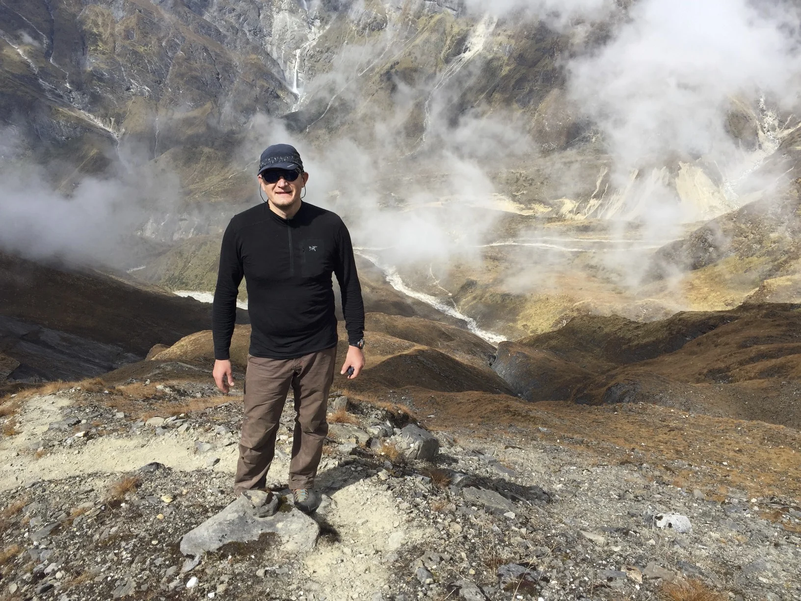
Today we decided to take a day off and enjoy the wonderful weather and the spectacular surroundings. I asked Siam to go on a hike with me. I wanted to climb a hill behind our camp as high as I could. It all looks so doable from down below, the small summit within an easy reach. Once I start climbing though, it becomes very tough. Once above 5,500 m the going gets really hard and each step is an effort.

The hill that we wanted to ascend is a part of a higher mountain that is over 6,500 m high. I would love to go to the top, but the altitude a makes it impossible in one day. So we decided just to go as far as possible for me, for Siam it was not a problem. The initial approach to the trail looked sketchy (up a rotten moraine) so David and Gilles pulled out before they even started. I was more determined so I plowed up. Once we passed the initial part, the walking up was very easy. We made it to the first knob and the views were already impressive. The massive bulk of Dhaulagiri towered above the glacier and the icefall below. The weather was perfect, sunny and with no wind. From the first knob at 5,000 m we decided to move up to the next visible knob and hopefully to the summit. Initially, the going was easy up loose scree then the grade got steeper. I could feel my pace and breathing getting slower. The loose scree at 45 degrees became nasty with three steps forward and two back. At the altitude, it tired me out pretty fast. I got to 5,500 m and I by that time I was really tired. The knob at 5,500 m was like a grand viewpoint perched above the valley. Across, the face of Dhaulagiri was gargantuan; we were almost even with the top of the Eiger Wall now. We could also see well above the icefall with the climber’s trail over the white ice field.

I was trying to pinpoint the spot where Polish climber Piotr Morawski fell into a crevasse at 5,800m. There was no obvious easy way up Dhaulagiri. Down below, the glacier snaked its way down the valley to the Japanese basecamp that was also visible in the distance. The distances here are very deceiving as the scale of the peaks is so massive. We could see all the way to the narrow gorge that we came from. To the right of the main Dhaulagiri glacier, was the massive Dhaulagiri 2 that is almost 8,000 m. The valley was now 1,000 m below us. We sat down and soaked in the vista and watched the clouds roll up from the valley below. We were above the cloud level so the peaks remained visible even after the fog moved in. It was magical.

After a short rest, we continued across the scree slope to a promontory with views of a cascading icefall (one of many in the valley). Another fantastic view. On the way down, the going was much faster as the scree is your friend now. We basically slid all the way in no time. We had to do a small detour and further down we went. I felt quite tired especially right before reaching the camp. I was hoping very much not to hit the wall (like on the Amphu Labtsa) as we were planning to climb Dhampus Peak in a few days, a 6,000 m mountain by the Dhampus Pass.

Near our camp on the moraine, there is another spot considered a basecamp proper. In 2014, in this spot an avalanche buried five people there after the earthquake. In that spot, there is a cluster of memorials to the climbers that lost their lives on Dhaulagiri. It is so sad to see that, as most of those people were healthy and young in the prime of their lives when they died. One of the memorial plaques had a photo of an unborn child (ultrasound photo) attached to it. Very sad. It must be difficult to die in such a lonely and inhospitable place. Faced with all these memorials, one has to wander what is the point of putting your life on the line for a hobby like mountain climbing? It is a cold, remote, lonely and unforgiving place. I could not find the memorial to the fellow Pole Piotr Morawski, his is also such a tragic story. He fell in a crevasse on the way to camp 1 on Dhaulagiri not far from the base camp where we were. Being here brings all these stories closer to heart and the ghosts of these people still live in the glaciers above. You can feel their presence.
Jerzy Kukuczka, another famous Polish climber, also walked across the French Pass into Jomsom when he climbed Dhaulagiri in winter. We were to walk in his footsteps.
In the evening we had a glorious light and cloud formations for photography. It is such a majestic spot. The night here at the basecamp is very cold. I woke up and had to put on the down jacket. The icy wind was flapping the tent all night long. We could also hear rumblings of distant avalanches all around but we were safe perched on the top of the glacier far away from the seracs and icefalls. The night was miserable, sleeping on ice and with the cold wind. In the morning, the tent was in the shadow of Dhaulagiri and the Eiger Wall. The temperature was -10C. It was not a place to linger, as the sun would not come until 9-10 am from behind the bulk of Dhaulagiri.
October 27, 2017 Dhaulagiri base camp – Hidden Valley camp at 5,050m via French Pass at 5,380m
We got up early anticipating a long day. It was cold in the shadow of the mountains in the morning. I started walking in my down jacket up a side glacier leading to the French Pass. The Pass was a very long way away although we could see it in the distance. We walked up a giant moraine and continued on its crest to the slope leading to the French Pass. The area was remote and desolate with great views all around. It is a high altitude desert: brown shale, very windy and barren. I was ahead of David and Gilles by an hour. I walked up to the Pass and as soon as I cleared the ridge, strong wind hit me with full force of a gale. The prayer flags on the pass were arching and flapping violently in the air.

On the pass itself, there was the memorial to Piotr Morawski that I was looking for. The memorial had an inscription from his wife and children: “You died doing what you loved leaving behind those who loved you”. A very sad story. I waited for 45 minutes for David and Gilles and took photos and video of them approaching the pass. The view of Dhaulagiri from the distance was very impressive. The entire mountain stood desolate towering above the valley. The slopes of Dhaulagiri are littered with many dead bodies as indicated by the numerous memorials we passed along the way.

Looking the other way, the entire Hidden Valley spread before us. It was barren and desolate. There were no trees and it looked like Mars: red and brown. The red valley floor was flanked by brown hills 6,000 m high with glaciers flowing gently from their round summits.

We walked down to the distant camp that was visible from the top of the pass. The descent was quite fast in brilliant clear weather under a cobalt blue sky. Once we got to the camp, relentless wind started to blow flapping the tents around. The camp is located at 5,050 m and it was cold, desolate and very windy. That night, the altitude made it impossible to sleep. I went to bed at 7pm, tossing and turning until midnight, some light sleep until 4 am, then awake until getting up at 5:45 am.
In the morning, the sky was clear, the wind was blowing hard and the place was cold! It was minus 20C outside and not much warmer in the tent. The wind was making the temperature feel even lower. My hands were frozen in seconds when I took my gloves off; the tent was completely covered in frost inside. We all had a shitty night with minimal sleep. The original plan was for Gilles, Siam, and I to climb the Dhampus Peak and to meet David and the porters at a high camp on the slope below on the other side of the pass. Although the weather seemed perfect, we decided to skip the Dhampus Peak, which later turned out to be a very good decision.
October 28, 2017 Hidden Valley camp 5,050m to Yak Kharka 3,820m via Dhampus Pass 5,380m
We got up early to the freezing temperature of minus 20C. Although it was sunny, the clouds started rolling over the pass early, which was unusual, as they normally do not come up this high until mid afternoon. We started walking to the Dhampus Pass in bright sunshine and it was a short way to the top. Again, I was there first and waited for everyone. The views of the Annapurna side were barely visible at this point as the thick clouds obstructed the panorama. The Thukche Peak next to the pass was visible through rolling clouds. As we descended to the other side, the clouds became thicker and blacker. Great for photos but it soon became apparent that we were walking into a raging tempest at 5,000 m. There was a clear demarcation line between the brown hill we were on and snow-covered slope ahead.

Once we crossed this snow line, the wind picked up, the blowing snow covered the track behind me in seconds. Initially, I walked with Gilles and we soon caught up to David and Siam. The wind was raging; it was a full on blizzard with horizontal snow and cold temperature. We could see nothing around us and the trail behind us got covered by snow very fast. The terrain became steep and the narrow icy path we were on became treacherous. At times, the blowing snow and ice (hail) would pelt my face like a sand blaster. The storm went on for the rest of the day and we walked right through the thick of it. Thank God for my down jacket and good gloves. Otherwise, I would be a frozen popsicle. We had no views except of this whiteout at 5,000 m. We did not want to linger as the snow accumulation would make avalanches possible later on making this route quite dangerous. Had we climbed the Dhampus Peak and separated from the others, it would have been impossible to find them and it would make our descent even more dangerous.
It was a long, tiring and a dangerous day. Gilles assisted some Americans with their descent, as they were completely unprepared, putting him two hours behind us. It turned out later, that it was their first time trekking in Nepal (and possibly the last). Gilles was in his element as he was praying for snow all along. He also found out how incompetent some of the Nepalese guides are since he basically had to guide the Americans down to the camp himself while the American guide ran off ahead of his group.
We arrived in Yak Kharka at 3,850 m after a long and steep descent from the snowy and windy slopes above. Soon after, the storm caught up to us in the camp and continued on with violent gusts of wind and horizontal snow. It was comfortable in the tent and the sleep was much better at this lower altitude than the day before.

October 29, 2017 Yak Kharka – Marfa 2715m
In the early morning the storm subsided and the magnificent panorama revealed itself from behind the swirling clouds. The fresh white snow blanketed the entire region. The sun was coming up from behind the Mesocanto Pass across the Kali Gandaki Valley in front of us. Across the valley, the wind was blowing plumes of fresh snow off the ridges of the magnificent Annapurna Group with the Nilgiri Peaks and the Annapurna itself right across from us. It was special for me to see the Mesocanto Pass from this side and it marked a completion of another installment of the Great Himalayan Trail for me. After a wonderful breakfast outside, we hiked up to a viewpoint at 4,000m for a great panorama extending from Tibet in the north to the Annapurna massif in the south. We could see Mustang, Thorong La, Mesocanto La, Tilicho Peak, Jomsom, and the peaks of Annapurna. We could also see down below, small planes coming to land in Jomsom air strip. After an hour or so, we continued down to Marfa. The descent from Yak Kharka to Marfa was a long 1,000 m of down, down, down. As we were descending, black clouds on the horizon looked ominous and threatening again.

We made it to the hotel just before the downpour started. It rained for a couple of hours. We ate, had a shower, dropped our bags and, after the rain, took a stroll to Marfa. It is a lovely, atmospheric town that managed to maintain its character and charm. It has a large well-maintained gompa (convent) in the middle with only 16 monks in residence. The gompa and the town have a good vibe and a positive feel about them. We came across a small bakery that makes a delicious apple crumble from the local apples. We had two pieces each.
In the evening, we had a party. Gilles bought two bottles of local Marfa brandy (a potent and strong brew). We had a dinner with formal tips ceremony, a make-feel-good speech by our resident good-will ambassador David, hand shaking, much drinking of apple brandy, and male- only dancing to Nepalese music played on a mobile phone. Stuff of my dreams. The Nepalese tunes were playing as loud as the phone would allow and the porters let loose by dancing together (this would never happen in the West where men must maintain their manly dignity in front of others). The levelled bed felt mighty good after many days of camping. It was a good rest and a mid point before I would continue on the Annapurna Sanctuary trek.
The following is the summary of the Dhaulagiri trek:
Start elevation 800m
Italian BC elevation 3600m
Hike in Italian BC 4300m
Basecamp 4600
Hike in BC 5500m
French Pass 5300m
Hidden Valley 5000m
Dhampus Pass 5300m
Elevation gain 6400m and the distance 90 km