

Kashgar – September 6, 2016
After a long and bumpy flight from Canada to Beijing and a long flight across China, I finally made it to Kashgar at 4pm. I visited Kashgar for the first time in July of 2001 as part of the 6-week trip to Pakistan. The colorful Sunday bazaar left quite an impression on me and I was taken with the sights and sounds of Western China. I wanted to return ever since then.
This time, the city was completely unrecognizable from the time I was here in 2001. The old city with its narrow alleyways was gone. The new section of the rebuilt old city seemed lifeless at first. I wandered around with sadness and disbelief but appreciative that I got to see the old Kashgar back in 2001. I do understand that progress in necessary and that people can’t live in squalor to preserve history. I guess that such rapid and complete change reinforces the awareness of the inevitable passage of time. Old memories of the time that has passed. The old Kashgar lives on in photos and books.

Soon after I arrived, I managed to get a haircut and a shave and had tea in the same old teahouse that Mike, Joe and I kicked back on large beds and had tea back in 2001. I have not done much exploring on my first day since I had a few days in Kashgar. I was really looking forward to exploring it (changes or not) as I missed a few important sights back in 2001.

Kashgar – September 7, 2016
I got up really early due to the time change (I hate dealing with jet lag). I had an interesting Chinese breakfast at 6am and by 7am I took a taxi to an important Afaq Khoja Mausoleum outside the center (5 km away). It is the holiest Muslim site in Xinjiang. The mausoleum was initially built in 1640 as the tomb of Muhhamad Yussuf, a Central Asia Sufi master who had come to this region of China in the early 17th century.

When I got there, the place was still closed so I had to wait for one hour. All places of worship have become museums in the new China. Because of this, these places are devoid of life energy and the spirit they embody. The empty halls had no sign of life or religious activities. The mausoleum had some beautiful architecture inside and outside the old buildings though, and the characteristic glazed green tile work of central Asia reflected the strong sunlight. The main hall was quite impressive with the carved wooden columns propping up the roof.
Next to the main hall, there was a stark Muslim cemetery. It did not take much time to walk around the entire site to see it all. The site was surrounded by tall poplar trees characteristic of Kashgar and this particular region. There were also the new gardens (a new addition, dilapidated even before finished). There was no one there and it was not very interesting.
After visiting the mausoleum, I walked back to the city. It was great to see the locals milling around. The Uyghur people of Xinjiang are very colorful and represent the spirit of Central Asia for me. I walked through the old bazar where the animal market used to be held. It is still a huge bazar with many stalls selling everything under the sun. I made a mental note to go back to the bazar after the trek.

After leaving the market, I ended up in the still occupied remains of the old city that have not yet been demolished. It was a sad almost abandoned and dilapidated ruin that would not be there in a few years. It obviously did not look good to live in but it was fully occupied. A Uighur lady invited me in to one of the houses. It was a dark, windowless, cramped firetrap. I climbed a cramped ladder to the roof for a better view of the surroundings. I can see why the Chinese demolished the old buildings. For starters, it would be impossible for a fire truck or an ambulance to get in. I am sure that the locals prefer the new to the old as well. For the tourists and for the nostalgic sense of history, the old is always better. However it is not a museum but a living city that evolves and develops like the rest of the world. The state of this last remaining part of the old city was so poor, that I think, it was just left to rot and crumble. I remember in 2001 that there were entire areas of old Kashgar that looked like that. Little did I know that the entire scene would not be there in a decade?
I ended up in the new/old town and noticed that the locals have embraced their new houses and just carry on with their daily business as they did before. Kashgar is still full of outside bakeries, meat shops, and sellers of all types, hawkers and barbecues smoking up the streets with the smell of shashliks. The city is extremely atmospheric where the Chinese look like all other foreigners. It is very interesting just to walk around and observe all the goings on.
I made my way back to the hotel to rest and resumed my explorations in the afternoon. I wanted to get to a lesser-known site of interest by taxi. I stopped a taxi on the street and showed the point of interest on the map to the taxi driver. He could not read Chinese, English or even the map for that matter. He drove me in the opposite direction and suddenly stopped in the middle of the road totally confused and refused to go any further. I left his taxi equally confused.
I flagged another taxi and the same happened. The driver could not read the map in Chinese or Uighur. Finally some passerby explained the directions to him and he took me. He took me part way to the giant Mao monument and I had to walk from there. The lesser sites were just that, lesser, and not worth the effort at the end. Very little if anything remains of the original old Kashgar from the books of Shipton.
Again, I hiked back to the hotel across the town enjoying the new/old city, eating watermelons and shashliks along the way. It was very enjoyable to just wander around, getting lost in a foreign place and just explore. A true joy of traveling. The local bread is to die for. When it comes from the hot outdoor oven it is extremely tasty and crisp. It is cheap and filling. The bread is shaped like a large pizza pie and sometimes it is sprinkled with various spices for taste. Another staple of the street food are the mutton skewers with onions. Absolutely delicious. The melons, grapes, apricots – all sweet, fresh and locally grown. Also there are many varieties if nuts and sweets. All very good. One could spend a week just eating various foods from morning to night. In the evening, most of the central streets become outdoor restaurants. The smell of barbecues and the ambiance of the crowds make the food taste better too.


On the way, I went to the grand mosque in the main square. The ticket price was 45 RMB! Wow! And really, there was nothing inside. It is good though that the Chinese have not alter the mosque.
September 8 and 9, 2016 Kashgar

Today the rest of the group arrived in Kashgar. David, Janik and Walid came from Bishkek. In the morning we did the city tour as a group. We basically retraced all the steps I did on my own the day before. We tried some good local ice cream (having Waheed, our guide, with us opened some new possibilities) and went for lunch to a good local restaurant. After lunch we went to see the famous Shipton Arch. It was a very nice drive through the outskirts of Kashgar and into the desert north of the city. The Arch is the tallest natural rock arch in the world and it is located 70 km outside the city in a very remote and desolate surroundings. The Arch is 460m tall (the same height as the Empire State Building). The Arch was made famous in 1947 by Eric Shipton during his tenure as the British consul in Kashgar. He described it in the book ”Mountains of Tartary”. The parking was at an elevation of 2,400m.

We followed a dry riverbed for some distance to a narrow canyon that was very narrow in places (we had to squeeze through it sideways). The Chinese installed metal stairs in the steepest and the narrowest sections. Finally after 45 minutes or so, the riverbed turned to the left and the Arch came into view. We had to climb up the stairs to a grassy saddle to get to the best viewpoint. The Chinese did a very good job with the trail I must say. The Arch was much bigger than it looked on the photos that I saw in the National Geographic some years ago. It was not possible to climb to the top of the arch without ropes, as the walls are vertical in places. The Arch is orientated in the north south direction making the light for photography challenging. Walid tried to climb the Arch with his sandals putting himself in a pretty precarious place as we all watched in amazement. After admiring the Arch for a while and taking some photos, we retraced our steps and drove back to Kashgar in the dusk.
On the 10th we were supposed to go to the Karakul Lake but after driving for 1.5 hours, we arrived at the road blockade and learned that the road ahead was washed away and it was closed for repairs for a few hours each day. Since the wait for the reopening of the road would have been a few hours, we decided to drive back to Kashgar. On the way, we stopped at the mausoleum of Al Kashgari a Uyghur scholar from the 12th century who translated the Koran into Turkic language of Central Asia. The hill behind the mausoleum provided us with some hiking and great views of multi colored canyons around the site. All in all, a good little hike.

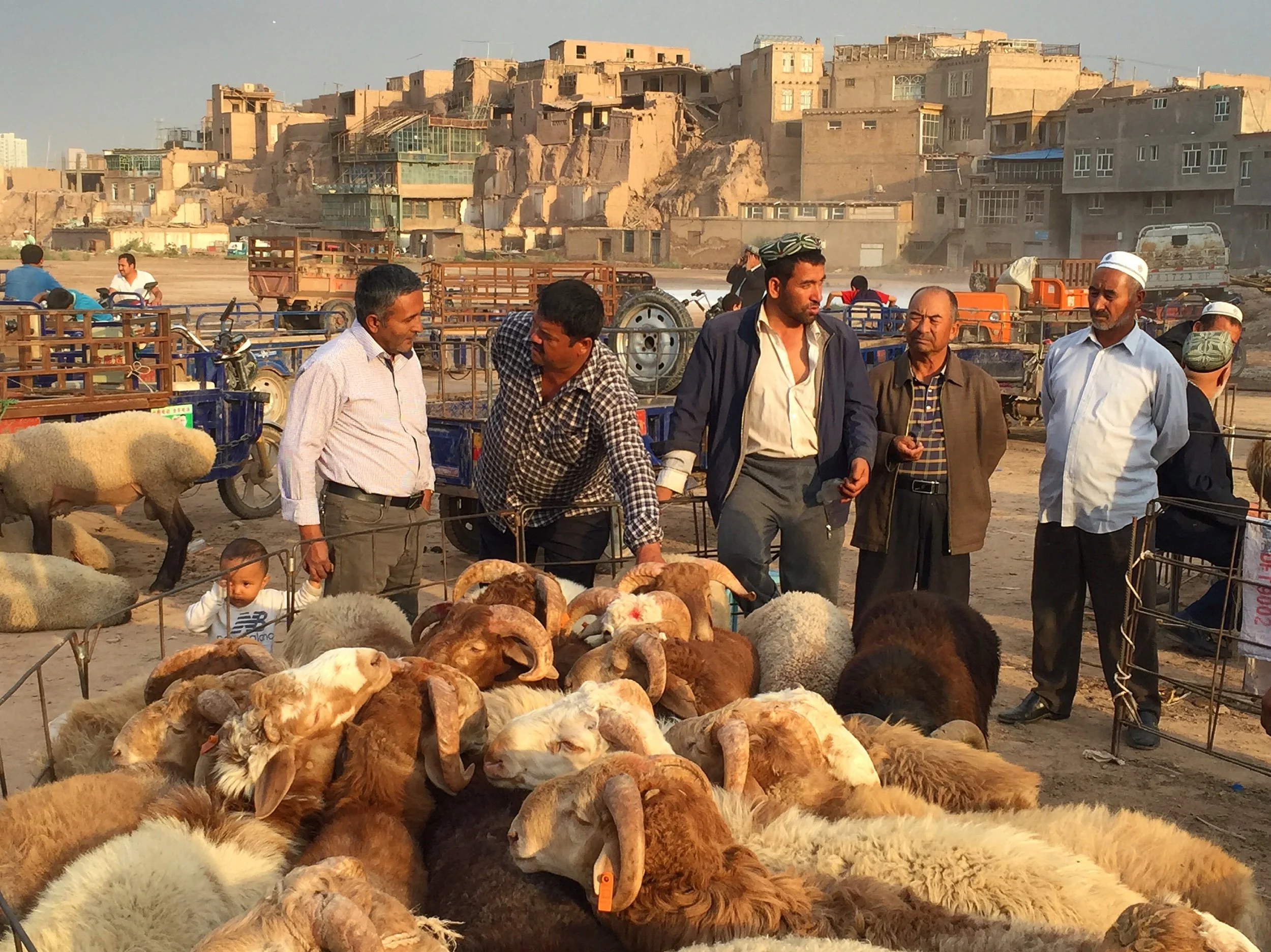
After arriving in Kashgar, we went for a walk in the new/old city and came across an animal market located just in front of the ruined old original city I visited a few days before. The old city provided a great backdrop for the animal market. The dark clouds, the setting sun and the evening light made for some great photos. It reminded me of the last time that we were here in 2001.
Tomorrow we depart for the K2 trek!
September 11, 2016 Kashgar – Karglik
Before we departed for our K2 trek, we visited the Kashgar animal market. The market was held outside the city in a less picturesque venue than in 2001. It was also removed from the main bazar providing for less people and ambiance. There were no horses and no horse riders testing the horses before purchase. We also did not see any pigeon salesmen. The spirit of the old market though, as I remember it, still lives on. The place was packed with animal traders. On the periphery of the main market area there were numerous food stalls serving traditional Uyghur foods including hand-made pasta. It was fun watching the cooks swing large ropes of the raw pasta in the air. The watermelon salesmen were scattered around the entire market serving delicious sweet Kashgari melons. The mountain of rinds was usually an indication of how sweet and good their melons were. Overall it was a very enjoyable experience with many photo opportunities. I love this part of the world for its people and their delicious foods.


After visiting the animal market, we had an uneventful 4-hour drive from Kashgar to Karglik on the Kashgar – Lhasa Highway. We could see the mountains in the heat haze in the distance for the first time (not Karakorum, perhaps part of the Pamirs).
Karglik was much more militarized than Kashgar, apparently because it is close to the China Pak border. We walked around town that was just a massive open-air super busy bazaar as the next day there was a Muslim holiday and everyone was out shopping. The main square area had a great old mosque with prayers in progress as we entered. The square and the area around the mosque were jammed packed with people shopping for foods, sweets in particular. The place was hopping.


We stayed at a sleazy hotel with a karaoke bar. In my room, I had an assortment of disposable underwear, condoms, lubes and all paraphernalia for a good time.
September 13, 2016 Karglik – Ilik
Today at 9am we left Karglik for Ilik that is around 300 km away. The drive started in the rain and a thick layer of clouds covered the mountains we drove through. We were divided into 3 jeeps. At first, the drive was through the flat desert-like outskirts of Karglik. After 70 km or so, it became quite dramatic and we started to climb up a steep series of switchbacks to a 4,000m pass with great views over dramatic rocky crags. We were following a massive Chinese military convoy consisting of at least 100 trucks. I admired their truck and how rugged they were to handle such challenging roads.
The scenery could rival the Karakorum Highway (KKH) in Pakistan in its drama and grandeur. From the high pass we descended into the Kun Lun Mountains through a series of serpentine switchbacks. The further we drove, the better the scenery became. We drove through deep and steep canyons, steep mountains with extremely rugged peaks, dry and inaccessible. In some places, the scenery was even more dramatic than the KKH except it did not have the Indus River raging below us.

As we drove further south, the scenery became even more dramatic. At a rundown truck stop called Mazar we left the main Xinjiang – Tibet Highway and turned south towards the Karakorum mountain range. We drove in a deep canyon of the Yarkand River surrounded by steep and massive mountains of the Karakorum Range. After the last military checkpoint, we arrived in Ilik village.
We settled into the house of the village Imam Daniel. We all slept in a large room on a sea of carpets. After a good dinner and a beer, we were off to bed at 8 pm. I felt like I was on a high school trip sharing a big communal room with my trek mates.
September 14, 2016 walk from Ilik to Susukoshulush Alt 3,750, 20 Km, 35C, 22,470 steps
We got up early and David and I went for a great walk up the Yarkand River valley. The rising morning sun provided us with great light for photos. The area felt wild and remote. It was a great feeling that we were finally on the doorstep of the Karakorum.
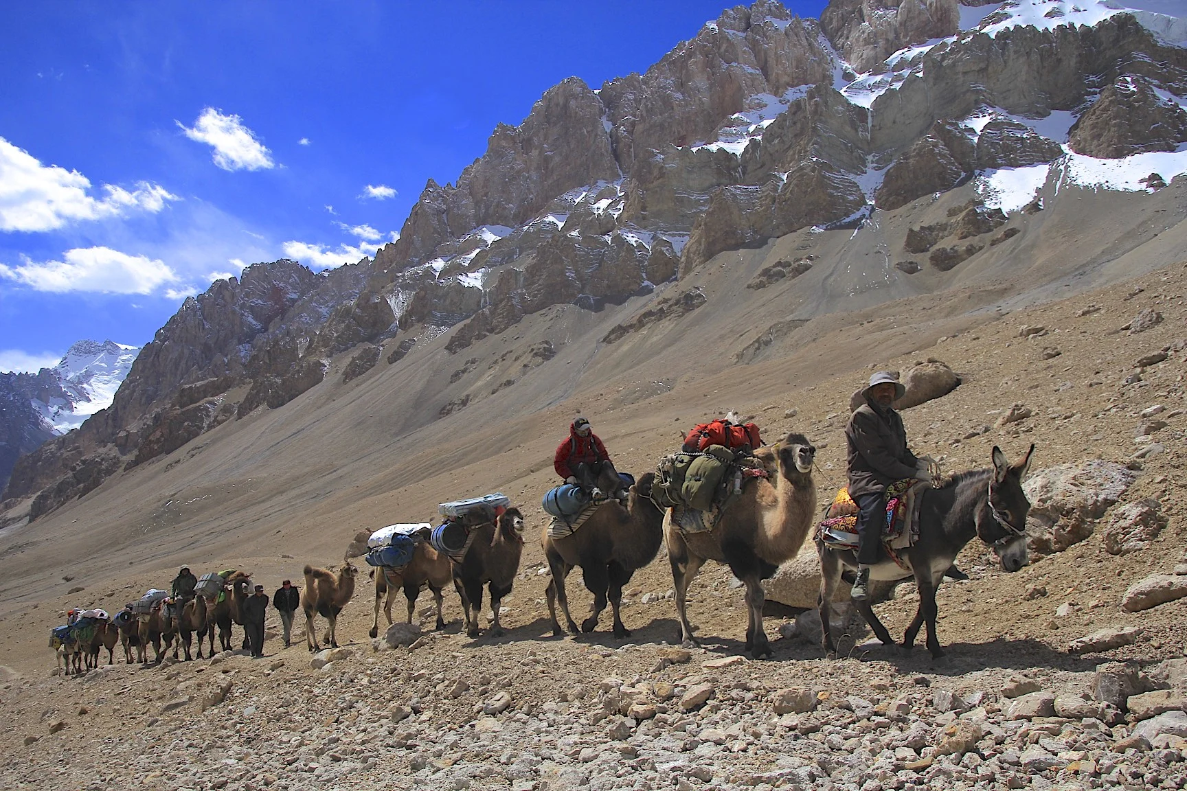
After the walk, we watched the camel men arrive and assemble the loads for the camels. We had 10 camels (including a baby camel in training), a dog and couple of donkeys. The camels were handled by 3 men who took care of them. The men were:

Ushukar or Ushur who was 60 years old and as agile as a cat, he had been a camel man since K2 was first opened to foreign expeditions by the Chinese in the late 70s early 80s,
Amed – 31 years old,
Idris – 19 years old.
The name of the head camel was Karbugra. The head camel is important as he sets the tone for the entire caravan. As the head camel goes, the other camels follow.
The name Karakorum means Great Rock in the Turkic language (Kara means great and Korum means rock).
Our chef was a Kirgiz man and his name was Abdul Karim. Our guide, Waheed, was the owner of the agency that organized this trip and he was a Uyghur from Kashgar. The name of the agency was Silk Road Expeditions. David and I used their services just a few months prior on a trip through the Taklamakan Desert.
The camel caravan was a unique part of this trek. Such mode of transport is not found in the Pakistani Karakorum or in Nepal. I like these graceful animals and walking along the caravan made us feel like true explorers. I was looking forward to taking great photos of the caravan along the way. The caravan of camels in the rugged surroundings of the Karakorum Mountains made for a fine combination.
The great walk of today started at 9 am. We walked up a broad valley with dramatic scenery of the river below. We could see glaciated peaks not too far away.

The sandstone cliffs above the river were at least 50m high. The weather was very nice: scattered clouds, blue sky and a lot of hot sun. Everyone in the group was gelling very nicely. We all walked at our own speed.

We arrived at a good campsite located at the bottom of a dry river channel. The sandstone cliffs towered at least 50m above the campsite. These cliffs are an interesting feature of the dry landscape of the north side of the Karakoram and are not found on the Pakistani side.
I was quite tired at the end of the day too. It was hot and being the first day, I did not feel quite acclimatized yet to handle all day of walking at 3,700m. I had a little headache all night but it disappeared in the morning. Fiume, a Chinese lady from Vancouver, fell flat on her face at the end of the day, dead tired.
September 15, 2016 walk from Susukoshulush to Aghil Pass camp at 4,250m 14 Km, 18,680 steps
The day started with crossing of numerous small streams and rivers. For the first 2 hours we continuously crossed water: sit, change boots to crocks, back to boots and repeat. At some point I just gave up the boots and walked in the crocks. The trail ascended a river valley up to a narrowing in a deep canyon. Then, the trail took a sharp turn to the right and climbed up a tributary stream coming down from another narrow valley. Rugged mountains surrounded us and the dark rain clouds on the horizon indicated that it could start raining at any time. The weather was unsettled and it did snow later that night.

The walk seemed longer than it really was. Eugenie had a mental breakdown in the camp and Fuime was totally done (maybe from altitude issues). She actually arrived at least two hours behind everyone else. She was sent down with one of the camel boys back to Ilik the following day. Although the terrain was relatively flat, it was very rugged. Combined with the heat and dust, the effort was just too much for Fuime.

Once we arrived at the camp, I went for a little acclimatization climb. The hill turned into vertical red rocks quite fast so I could only go up a few hundred meters. The view from the highest point was great never the less. The stormy sky provided great ambiance for photos. From the high point I watched Waheed and Fuime arrive in the camp late and very slowly.

The night was quite cold and it rained and then snowed. The rain clouds descended all the way to the bottom of the valley and it did not look good for the pass crossing. The tent was covered in frost inside and it was totally wet. Since we were sheltered from the sun by high mountains, nothing dried in the morning.
September 15, 2016 Aghil Pass camp – Aghil Pass – Shagskam River camp 1 3,940m, 30km, 39,000 steps. Cold and windy on the pass.

We got up at 6 am (before sunrise). Due to the altitude I woke up a few times during the night. It was difficult to sleep at 4,250m since I was not yet fully acclimatized. From our camp, it took 2.5 hours to get to the Aghil Pass at 4,750m. The pass is quite broad and open but vey windy. It is flanked by mountains with hanging glaciers on both sides. It felt really special to be there given the history of exploration associated with it. The view from the pass was excellent to the north Gasherbrum Glacier and peaks that I mistakenly thought were the Gasherbrum.

The famous Shakskam Valley was down below and I was happy to be finally here. The scenery was very grand but different from the Pakistani side. Although we were not on glaciers, the dry river valley flanked by needle like mountains was very dramatic. The descent from the pass to the Shakskam River was very, very long. By the time we descended to the river itself through a weakness in the sandstone cliff, it was late afternoon. We crossed the Shakskam River on camels for the first time, the experience that I found to be quite unnerving.

The camels were attached to one another forming a long train with the camel man riding a donkey in front, pulling the head camel by a spike in the camel’s nose. We all sat on top of loaded camels on unstable bundles of bags tied to each of the camels by ropes. Once the camels started to move, the entire pyramid of stuff with us on top swayed back and forth and sideways and shook, making it feel very unstable. We arrived at the sandy camp quite tired and late. It was a very long day.


September 16, 2016 Shakskam River camp 1 to Shakskam River camp 2 plus hike to K2 viewpoint. 40,000 steps 3,950m.
In the morning we were told that today we would have many camel assisted river crossings. Somehow, the camels went ahead. I separated form the group and crossed the Shakskam River myself following the camel train. During the day I crossed many channels but only once I felt uncomfortable with the murky cold water of the Shakskam River. The experience of crossing many rivers in the Arctic came in handy today. I actually found the experience of crossing the river fun, as I had to look for the best place to cross, like a puzzle.


Once I got to the other side of the main Shakskam River channel and caught up with the camel train, I realized that there was one more main channel to cross and it looked too deep for my comfort. I hopped on the camel and before I knew it, I was on the other side. Once I dismounted, I saw our group in the distance in great agitation running up and down by the riverbank. Obviously someone fell in the river. I alerted the cook who had a minimal understanding of English to ask the camel men to go and help. They however, had prayers to take care of first. They dropped to the ground in the middle of the stone covered valley of the Shakskam and started their prostrations to Allah. After 15 minutes or so, they went back to retrieve the group from the other side of the river.

As the camels with the group members made their way across the main channel, I watched as David fell of his camel backwards and landed in the river on top of his backpack. Then Mike almost fell off too, hanging by his fingernails. He looked very precarious and he was barely hanging on. It turned out that Eugene fell in the river while trying to cross it and was swept away. Walid and Gilles jumped in and helped her out of the water. After the adventure, it was another hour to the camp.

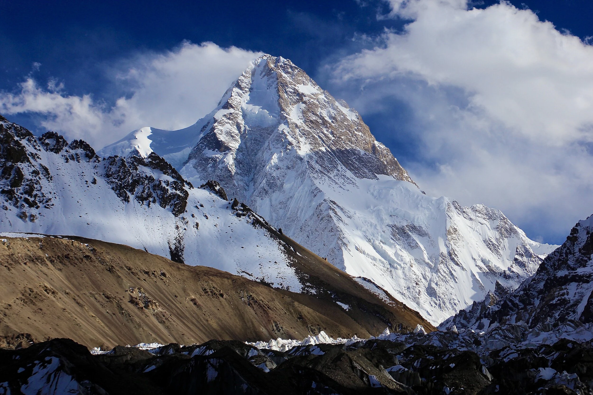
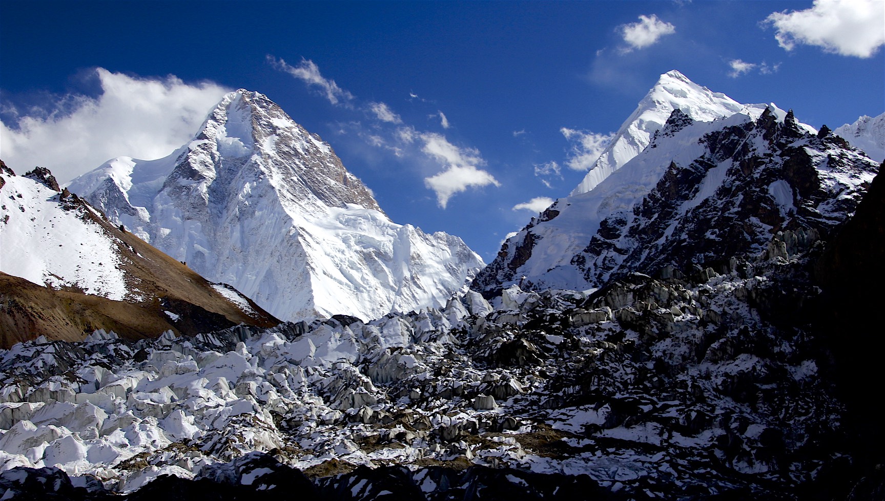
As we were approaching the camp, I saw a trail snaking up a hillside in the distance. After arriving in the camp at 15:30, I asked Walid if he wanted to go up and see what was up there. On the map it looked like we could get to the top of one of the mountains flanking the river valley. We climbed up to a series of ridges that formed a pass between the Shakskam River Valley and the Muztagh River Valley where the Chinese BC was. From the top of that pass, we got our first incredible view of K2. It looked impossibly steep and high. It was partially covered in swirling clouds. We could also see the entire area around the Chinese BC, the surrounding mountains and up the Sarpo Lago Valley. A grand panorama in a great late afternoon light. As it was getting late and quite windy, we turned around and made our way back to the camp. It was a fine hike.
Along the way I found a skull and horns of a Himalayan Blue Sheep. I took it, although it was quite heavy, to give to Gilles. He was not too keen on taking it, but Walid wanted it. He put it in his duffel bag only to later drop it from fear of an airport search.


September 17, 2016 Shakskam River Valley2 to Shipton Camp (Chinese BC) 20 km, 3,850m
We started in brilliant sunshine and beautiful weather. It was supposed to take only 3 hours to the Chinese BC but it actually took us 7-8 hours with a river crossing at the very end. The last few hours were on the flat never-ending stone plane. It was quite tiring and boring, like walking across a massive gravel pit.


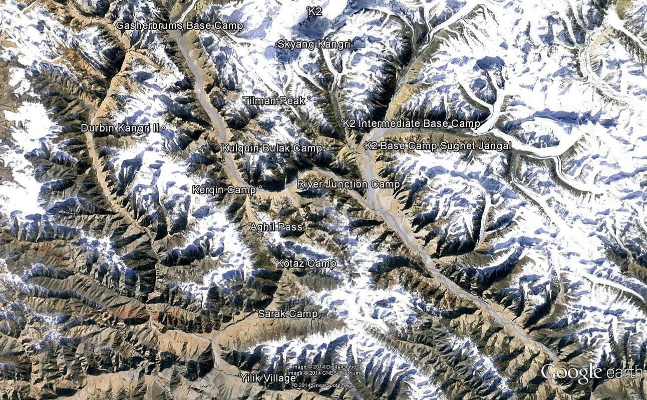
We had to cross the Shakskam River a few more times. Once we rounded a corner, the beautiful pyramid of K2 appeared again in the distance. As before, K2 was towering over the entire range and the glacier below. After we turned from the main Shakskam Valley, the Muztagh River stretched before us on the large gravel plain. Three large valleys feed the Muztagh River Valley: the K2 Glacier Valley, the Sarpo Lago Glacier Valley and the Crevasse Glacier Valley. The Sarpo Lago Glacier is very long and terminates at the Trango Pass in Pakistan (the very pass used by Shipton to enter this region from British India). The Crevasse Glacier leads ultimately to Shimshal Pass, also in Pakistan. The K2 Glacier is the one we were supposed to explore. The rivers draining each of the massive glaciers are large. The Sarpo Lago Glacier and the Crevasse Glacier flow from large ice fields at their upper ends. This is the wildest and the most rugged high mountain area in the world. The best area in the world for trekking, climbing and exploration. It remains the least explored mountain range in Asia.

After today's walk, I was quite exhausted. The walk was much longer than expected and the heat that was beating us down added to the tiredness. The river draining the K2 Glacier was the last obstacle before we reached the camp. It was fast moving and turbulent but not too wide or deep. One of the camel men was waiting for us at the river with a donkey and a camel. Mike crossed on the donkey without a problem. When I got on the donkey, my long legs basically dragged under the donkey in the water, hitting the boulders in the river. It was quite amusing to everyone. I probably could stand up straight over the donkey and the small donkey could just walk under me. I should have just walked across the river with my boots on and the result would have been the same.
Once we crossed the river, it was another mile or so to the camp proper. We were getting increasingly impatient to arrive at the camp as we run out of energy. We walked by the memorials dedicated to climbers who died on the K2’s north face: Chinese, Japanese and Russian.

Finally we reached the camp that was situated in a large oasis full of small bushes with lush green grass and a clear stream flowing through it. The Sarpo Lago Valley and the Crevasse Glacier were visible from our camp. Shipton and Tillman used the same camp during their exploration of this region in 1937. It was a beautiful spot with green grass and wonderful views all around.
September 18, 19, 20, 21, 2016 K2 Glacier 25 km each way 4,700m
We started the walk to the K2 glacier after lunch and walked to the Pakistani BC at 4,000m over a large hill right behind the camp. We walked in beautiful weather. As we reached the top of the hill, the view to the K2 glacier and K2 at the end of it, opened up. The black snout of the K2 Glacier with the K2 River emerging from under the glacier was right below us. The descent to the Pakistani BC was down a steep moraine on a very narrow path with a 100m vertical drop to the rocks below. It took us 3 hours to get there. At the Pakistani BC a German group set up their kitchen tent that we borrowed to eat dinner and breakfast the next day. In the evening we had a fabulous view of the sunset on the K2 pyramid. The night was clear and cold.
The following day, Mike and Eugene decided to return to the Chinese BC and after they left, we continued on to the Italian BC. At first, we had to cross a field of very large wobbly boulders, then up a rotten moraine that partially collapsed in a recent landslide. We finally reached the Italian BC after 3 hours of uphill walking. The Italian BC is situated at 4,350m. The view from this spot was magnificent. K2 was visible from the bottom to the top towering over the K2 glacier directly in front of us. We pitched our tents on an elevated platform above the glacier and facing K2. After lunch we went for a two-hour walk further up the valley to scope up the way for the following day. The passage forward looked shaky, the moraine was steep and partially covered by recent landslides. The glacier was quite broken up. Gilles and Walid went ahead and scoped up a route for the following day of exploring.

The next day we left at 9am and started walking up the narrow valley beside the K2 glacier. The terrain was quite challenging, as we had to negotiate numerous landslides with the broken black K2 glacier to our left. The towers of ice above us were 20-30 m high and were becoming more and more jumbled the further we went. After 3 hours we finally reached a moraine and the side glacier that blocked any further passage.

On the right hand side there was a large hanging glacier descending steeply over a rock cliff ultimately connecting to the K2 Glacier. This side glacier consisted of huge jumbled crevices that were impassible. In front of us, the K2 Glacier was heavily broken up and was joined by other large glaciers in the distance flowing down from the Chongtar Amphitheatre. The peak of Chongtar II South, 7,180m and Chongtar I, 7,315m was right in front of us. We were now 155km from the starting point of our trek and 7 to 10 km from the base of K2. Yet, the mountain was huge and seemed to rise vertically in front of us. As Tillman said: “attracting with its grandeur and repelling with isolation”. We spent a good hour with Walid admiring the views.

After some time, the rest of our group appeared in the distance: Gilles, David, Janik and Waheed were sitting 800m away and not moving any further. Finally, Walid and I decided to go down and meet with them. Once we got to them after 25 minutes of walking, they were quite upset that we run ahead of them. We offered to take them back to the viewpoint where we were a short while before. It was a good thing that we went back as the lower afternoon light was much better for photos. We lingered there until 4.30pm and then went back to our camp at the Italian BC.
On the way back to the tent I saw a good photo op that required me to descent a steep moraine to a pool of water reflecting the pyramid of K2. Once I got down, it was impossible to get back up and I had to continue down in a narrow water filled gully squeezed between the steep moraine and the glacier itself. I got back to the tent just before it got dark, wet and quite tired. Waheed and Janik got stuck in the dark without headlamps and we had to guide them with lights and shouting indicating the location of the camp in total darkness.
The following day, we almost run out of gas for cooking before we started our descent back to the Chinese BC. All in all, we had great 4 days of exploring and definitely it was the highlight of the entire trek. After all, this is why we came here: to see the K2 and the K2 Glacier. We were very lucky with a spell of such fine weather and awesome views of K2. I was not so lucky in Pakistan in 2001 when the entire mountain was covered in clouds. When I was at the K2 BC on the Pakistani side, it rained.

As we were descending down to the Pakistani BC, the K2 was hidden behind a thick cloud cover. It looked like it was snowing further up the K2 Glacier where we came from.
The forecasts that Dreena sent me via the sat were quite accurate. I really wished that I had more time to explore this fantastic region and I felt rushed to had to go down so soon.
Once we arrived back at the Chinese BC we were quite tired. We had 9 days of nonstop walking over the distance of 200+ km. I took the afternoon to wash up and wash some of my clothes as well.

September 22, 2016 Rest Day – Hike to Sarpo Lago Valley
Today was a rest day for some but I decided to go and check out the Sarpo Lago Valley that we saw in the distance. This basin is such a great area to walk around and explore. The entire area is huge and it would take a couple of weeks to properly see it. The entrance to the valley looked near but once I started to walk, it did not seem to get any closer for a long time. I walked for 8km by myself to see if I could get to the snout of the Sarpo Lago Glacier but I clearly underestimated the distances. I could see the Crevasse Glacier across the Muztagh River and a sea of massive peaks lining its sides. It all beaconed to me and I wished so much that I had more time to go there. Later I asked Waheed about a possibility to do an exploratory trek there and he told me that the Chinese would not issue a permit for it.

I was surrounded by distant storms that provided excellent backdrop for some dramatic photos. One of the mountains had a dark cloud forming on its summit that made it look like a steaming volcano. I enjoyed the walk very much, the silence, the solitude and sense of exploration. There were no people around us for at least 100km radius. It was a true mountain wilderness. I returned to the camp at 6pm just in time for dinner.

September 23, 2016 Chinese BC to Shakskam River camp 2. 17.8 km, 28,000 steps

Today felt like a long day mainly because I was getting tired. We were now approaching 200km mark (with my extra 20km walk the day before). The morning weather was brilliant allowing us to get the last view of K2 in the morning sun and blue sky. From the distance, K2 looks much higher and steeper. It is like a giant tooth, steep, almost vertical.
At lunch David and I caught up with the group and Walid was missing. We shouted and looked for him and got quite worried. Waheed, the guide, went looking for him and while he was gone, we spotted Walid far away with binoculars. Mike got really angry, as it was not the first time that Walid just took off without telling anyone.
As I am writing this at the dinner table at the camp, the two Ws are not here yet and are at least 1.5 hours behind. We had to cross many rivers today and ride the camels that were wobbly and unstable. The camel men would not wait for no one and we basically had to follow them leaving Waheed to look for Walid. During one of the river crossings, I fell of a camel and jumped back just in time avoiding a wipe out. The second time, the old camel man plopped me on the most unstable load in the caravan. I ended up sitting on a blue plastic crate that was tied to the mountain of bags 15 feet off the ground. Just when we reached the edge of the Shakskam River, the crate rolled throwing me off and again I jumped off just in time. Had it been a few seconds later, I would have ended up in a fast flowing river. I was officially done with the camel riding.
When the camel begins to cross the river, it steps down from the bank into the river channel. The bank is 1 - 2 feet high. The camel moves down and forward stepping off the bank, making the cargo shift forward as well. One has to hold on for dear life in order not to fall forward. When the camel exists the river the motion is repeated in reverse and the movement is backward. One has to hold on very tight not to slide off the camel. The entire process is like riding a rodeo horse in slow motion but sitting on a mountain of unstable cargo and surrounded by a fast flowing river.


When Waheed finally found Walid, they realized that they were left without a donkey or a camel for river crossings. It was now late afternoon and the river’s volume increased. Walid’s legs are quite long but poor Waheed is like a blue expedition barrel: round and maybe 5 feet tall with short legs. Any river crossing without a camel would be quite a challenge for him. When the river was swollen, it was almost impossible. It took the two Ws a few hours to find shallower channels to cross without the aid of the animals. Walid arrived first and was pretty shaken up. He damaged his phone by getting it all wet in the deep river. He did apologize to everyone though and all was forgiven rather quickly. Mostly, we were just happy that no one was hurt.
After the arrival and reconciliation, we were watching one of the determined camels escape his captivity and run down the valley almost the entire distance covered by us today. We were rooting for the camel and cheering him to run all the way to Pakistan where he would be free and could roam the valleys. Unfortunately for him (but good for us) he was captured and brought back were a lesson of submission was waiting for him from the head camel man. It was established who was in charge. The camels are quite feisty and have big personalities: aloof and proud but stubborn. Every one of them is different.

September 24, 2016 Shakskam River camp 2 to Shakskam River camp 1
After making up and group hugs (mainly spearheaded by our acting morale officer Gilles), we were all friends again. We had many river crossings again but I was dead set against getting back on one of the camels. I decided to cross the river on my own and David followed me. He was done with camel riding as well. At one point we got to a spot that seemed impossible to cross. The main channel of the river was fast and deep. I managed to get across but poor David lost his footing and I had to catch him before he floated away. We were quite fashionable walking down the Shakskam Valley in nothing but our underwear.


After a long day and many river crossings, we made it out of the Shakskam Valley to a new campsite overlooking the massive jagged peaks across the river. Right next to our campsite, there was an entire hill made from red and gold sandstone. It was a great contrast to the white snow higher up making for some great photos.

September 25, 2016 Shakskam Valley camp – Aghil Pass – Aghil Pass camp
The walk up the Aghil Pass was tiring and long. At the top of the pass I decided to wait for the camel train to take photos with the views of the camels and the mountains behind. The wind was blowing like hell and it was bitterly cold. I parked myself behind a rock wall and enjoyed the magnificent view from the pass sheltered from the fierce wind. I waited for at least 40 minutes in this bitter wind and froze my ass off. When the caravan arrived, I saw Janik and Brigitte riding the camels. I was wandering how could they stay warm sitting atop a camel in this wind?
The pass, although wide, is surrounded by steep mountains and hanging glaciers. Just across the crest of the pass, there is a small lake that was mentioned in the Shipton’s book. The plateau around the Aghil Pass is very scenic. The descent seemed longer and I walked most of the distance by myself. I was surrounded by such grand scenery on all sides. It was sad to leave this place behind.


September 26, 2016 Walk down to River camp 1
Today we started yet again in beautiful weather. We left the Aghil Pass and the valley behind. We stopped at a Kirgiz herder’s hut and purchased a young sheep to cook later in the evening. It was quite expensive ($100 US). The two Kirgiz girls manning the camp stay there for 8 days until a replacement comes up from the village. They live in a very basic stone hut with minimal provisions. We had tea and watched the camel man kill the young sheep in a fast and efficient manner.
Later that evening we had a great fire with skewers of mutton from the sheep. The meat was excellent. We ate under the sky filled with magnificent stars and the Milky Way stretching across the firmament. The trek was almost done as the following day we would reach the road and meet our ride back to Kashgar.


This side of the Karakorum is very different from the Pakistani side: it is lower in elevation (4000m as opposed to 5000m); it is warmer and much drier. It is nice not to sleep on ice and glaciers.
September 27, 2016, finish and drive to Karglik
We walked for an hour to reach the waiting jeeps. We had a beautiful drive over the Kun Lun Mountains with fantastic views in great weather again. The drive through the mountains rivals the Karakoram Highway on the Pakistan side. It is almost better as there is no danger from terrorism. I remember when Ghulam (our guide in Pakistan) hired a driver to take us from Islamabad to Skardu. The driver looked like Osama Bin Laden and was hired for our protection. Ghulam reasoned that if any thug or a terrorist would see him driving, we would pass safely without being stopped. This was all that Ghulam could do at the time.
On the way to Karglik we stopped at a 5,000m pass for some spectacular photos over the Kun Lun range. The road we were traveling winds down the mountains like a giant serpent. The drive to Karglik took 9 hours over the distance of almost 300km.
The following day, we drove from Karglik to Kashgar via Yarkand. Yarkand is a famous Silk Road town that we wanted to see since we were driving by it anyway.

In Yarkand, we drove to the historical center and walked around the old town. It was worth seeing due to its historical significance. We walked by the Royal Tombs, the main Mosque and through the old alleys. After the short visit we left for a rather boring drive back to Kashgar through flat desert. Kashgar was 550 km from Ilik.


In Kashgar we took care of some last minute shopping and then everyone left to his or her respective destinations. I had another short excursion planned: Pamir and Tashkurgan. When we visited this area in 2001, I felt like we did not spend enough time along the Chinese stretch of the Karakoram Highway. Since I was already in Kashgar, I wanted to revisit it.
Summary of the trek:
278 km total distance walked plus 20to Sarpo Lago Valley and 5 to K2 view point = 300km
20 km a day on average
8,000m total ascent and descent
Temperature range from plus 38C to minus 8C
4,900 maximum altitude
40 river crossings
K2 Glacier is 43 Km long