
The Grand Mustang Circuit is a combination of the Annapurna Circuit (or what is left of it), the classic Mustang trek, the Terila Trek and the trek trough the Naar/Phu region. To finish things off in “style”, we returned to the starting point via Kangla Pass. The total distance of this EPIC trek was 380km which we walked over 24 days. We climbed 12km in total elevation (probably descended the same) and crossed 3 passes over 5,000m and a quite a few passes over 4,000m. Half of the trek is through sparsely populated regions requiring camping and self sufficiency. It is a spectacular route through some of the most culturally interesting areas of the Buddhist Nepal with a thriving culture. Again, many thanks to the Mountain Sun Valley and Rajendra for putting this together.
It is not technically difficult but it is long. It also has a lot of ups and downs, especially in the Mustang region, where one has to constantly climb into and out of river gorges that cut through the landscape. The trek offers spectacular scenery that is very different from what I have seen in other parts of Nepal. It is a truly unique experience both visually and culturally.
This section of the trek was particularly interesting from the cultural perspective. Numerous villages, each offering interesting sights and surroundings. The fantastic Tsarang and the historical walled city of Lo Mantang. Unfortunately our permit did not allow us to see all the signs so we had to choose the most interesting ones. There are 1,104 households in the Upper Mustang and 3,834 inhabitants. The highest number of foreign visitors to Upper Mustang was in 2014 (before the earthquake). 4,4146 foreigners visited Upper Mustang That year.


The town of Kagbeni (2,810m) is the beginning of Upper Mustang. You need a permit to go beyond Kagbeni. The permit costs $500 US and is valid for 10 days. Each additional day costs $50/day.
The town is located in the Kali Gandaki valley. The Kali Gandaki Valley is the deepest valley in the world. It cuts the Himalaya Range between Annapurna I and Dhaulagiri I, both peaks being over 8,000m in height. You can see the Kag Choede Gompa on the right of the photo. The large mountain in the photo is Nilgiri North 7,061m which forms part of the Annapurna massif.

The Kali Gandaki Gorge and the Kag Choede Gompa in Kagbeni. The sanctuary was founded in 1429. It contains many old paintings and artefacts.

Fantastic location of the Kagbeni Gompa - it faces north and south the Kali Gandaki valley.
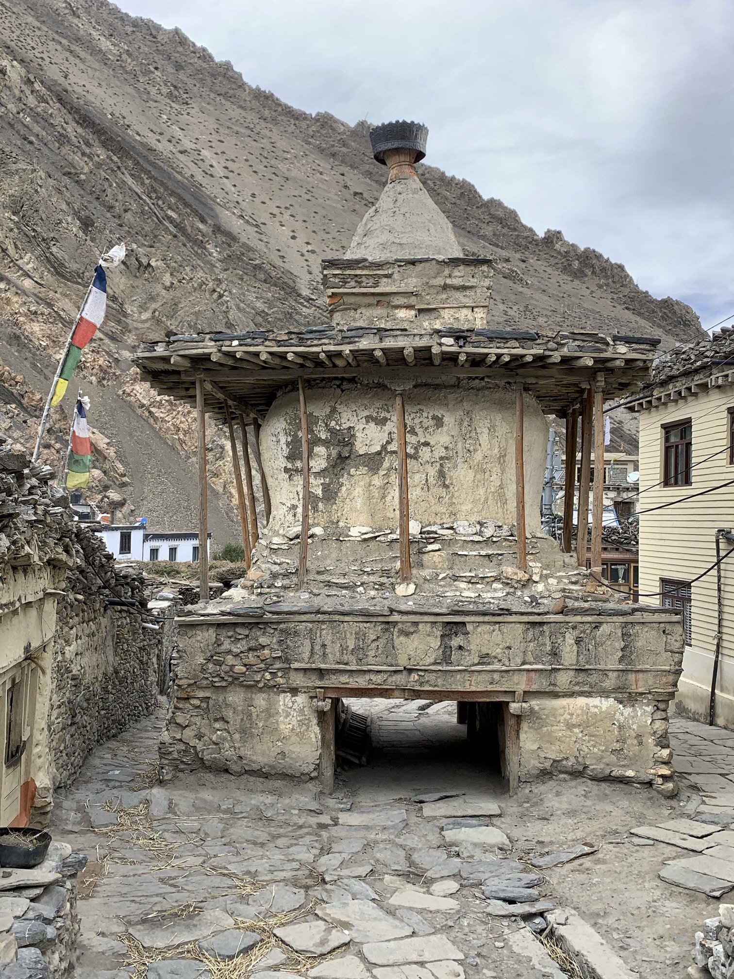
Kagbeni - a large old chorten at the entrance to the village.

The Kag Choede Gompa in Kagbeni

The beautiful Kag Choede Gompa in Kagbeni. The ritual masks are used in various festivals held in the Gompa’s large courtyard.


The Bhavachakra, the Wheel of Life or Wheel of Becoming, is a mandala - a complex picture representing the Buddhist view of the universe. To Buddhists, existence is a cycle of life, death, rebirth and suffering that they seek to escape altogether. The Wheel is divided into five or six realms, or states, into which a soul can be reborn. It is held by a demon or a god of death. Around the rim are depicted the twelve stages of dependent origination. The outer wheel depicts a blind man or woman (representing ignorance); potters (formation); a monkey (consciousness); two men in a boat (mind and body); a house with six windows (the senses); an embracing couple (contact); an eye pierced by an arrow (sensation); a person drinking (thirst); a man gathering fruit (grasping); a couple making love (becoming); a woman giving birth (birth); and a man carrying a corpse (death).
At the center of every Wheel of Life are a cock, a snake and a pig, which represent greed, anger and ignorance. In Buddhism, greed, anger (or hate) and ignorance are called the "Three Poisons" because they poison whoever harbors them. These are the forces that keep the Wheel of Life turning, according to the Buddha's teaching of the Second Noble Truth.

The village of Chusang (2,980m). Chusang is an interesting old village consisting of a walled, enclosed structure that looks like a fort. It is in fact a conglomeration of houses tightly packed together to protect from the vicious winds that blow through the valley every afternoon. The wind reaches speeds of 100km/hr and can blow small stones like bullets.

The Kali Gandaki River and fantastic rock formations surrounding the village of Chusang. The Kali Gandaki valley is the source of shaligrams, spherical, black-coloured Ammonoid fossils of the Devonian-Cretaceous period which existed from 400 to 66 million years ago. The fossils are a representation of the Hindu god Vishnu and the Hindu Universal Principle. The Universal Principle is the Ultimate Reality in the universe. In major schools of Hindu philosophy, it is the material, efficient, formal and final cause of all that exists.

The harvest in the village of Chusang. Somewhere below is the missing key keeper for the temple of Mentsi Lhakhang (see below).

From Chusang, we hiked to an interesting village of Tetang (3,040m). It is another walled village with a large monastery that was unfortunately closed. We also walked by a cave temple of Mentsi Lhakhang that was also closed. The man with the key was working in the fields and was unavailable. This sanctuary is over 1000 years old. I got to see part of it but the main hall holding the most ancient artefacts was closed. I quickly realized that each village has a gompa or a place of interest that is usually closed. One needs to locate the key keeper to gain access. This is not always easy.

The medieval walled village of Tetang.

Inside the walled village of Tetang

The Buddhist society of Upper Mustang is divided into groups comparable to the castes of Hindu culture. The occupational castes (the lowest) comprise blacksmiths, butchers and musicians. The highland nomads called the Dokpa take a slightly higher status. The middle class consists of the Phalwa who call themselves Gurung.The highest class is the Kudakpa and it includes the nobility and the royal family of Lo.

Large chortens outside Tetang

Tetang

Ancient meditation caves around Tetang

The chortens of Tetang

The walled village of Tetang can be seen on the hill in the distance. Surprisingly, only 5 families live there.

The village of Chele (3,100m). The road in the photo leads to the first pass of Bhena La 3,840m. The trail between Chele and Syangboche passes by the Rangchyung Cave Chorten (Chyungsi Cave). We wanted to see it and took the detour to reach it. It was the longest day of the entire trek and involved the most climbing over 3 passes.

On the road from Chele. Since it is an actual road, we were passed by jeeps and motorcycles on their way to Lo Mantang kicking up enormous clouds of fine dust. Thankfully it was only in the morning as the jeeps leave Jomsom (where tourists arrive by plane from Pokhara) early for a long drive north. After a couple of hours we left the road behind and did not see it until Lo Mantang.

The Annapurna Himalayan range from Bhena La (3,830m). On the left you can see Tilicho Peak (above Tilicho Lake) and to the right of it, Nilgiri North.

Looking east from the Bhena La Pass to the Terlila Pass. We crossed the snowy mountains on the horizon through the Terila Pass (5,600m) several days later.

The Annapurna Himalaya from the Bhena La Pass. Thorong La pass is on the left of the photo.

On the way to Rangchyung cave we had to cross two more passes of 4,000m. It was the longest day of the trek so far. The nature of the terrain necessitates a lot of climbing!


Respite from climbing! A 50m stretch of flat trail.

The Roc Noir of the Annapurna Range from one of the passes en route to the Rangchyung cave. The ridge from Roc Noir connects to Annapurna I which can be seen on the right upper part of the photo.

The canyon-land on the way to the Rangchyung cave.

The Rangchyung Cave (Chyungsi cave) is located at an altitude of 3,900m. The cave temple is said to be founded in the 8th century by a Tibetan mystic Padmasambhava who used the cave for meditating. The centre of the cave is dominated by a natural pillar rock with images of Buddha painted on it. A natural ambulatory leads around the rock to the naturally formed image of an Indian Guru Atisa.

Chyungsi Cave temple

The chortens built into the natural rock pillar inside the cave.


The monk and the temple custodian of the Chyungsi cave has lived here for the past 10 years. The cave, in addition to the main sanctuary, is divided into various rooms and areas. One room is used for reading, praying and meditations. There is also a kitchen area and storage. The monk in the photo is from Tibet and does not speak Nepali or English. We were welcomed by tea and fresh apples! He gets his supplies from the locals and occasionally from his family in Tibet. He was very gracious and showed us around.

On the way from Chyungsi cave to Syabgboche (3,773m) we had to pass through a narrow canyon that blocked all sunlight.

The trail between Syangboche and Ghemi (3,520m) crosses yet another 4,000m pass.

The wild rock formations around Ghemi

The village of Ghemi (3,520m). The pillar shaped rocks behind the village are dotted with caves. We explored them the following day.

The view from a pass before Ghemi.

Ghemi and one of the residents.

In Ghemi

The roofs of Ghemi with the Damodar Himal on the horizon. The Damodar Himal is located north of the Annapurna Range and is relatively little visited compared to the main trekking areas of Nepal.
The locals pile the wood on the edges of roofs for decoration, for wood storage purposes and as a wind breaker.

Old caves above Ghemi. We spent an afternoon exploring them. The cliffs are rather dangerous as the loose rocks dislodge with regular frequency. We spotted many Himalayan vultures that nest in the old caves. They were checking as out as a potential source of food.

Inaccessible caves high on the cliff. Most of the caves in Mustang bear testimony of prehistoric settlers. Little is known of their origin and life. The Tibetan and Ladakhi chronicles have mentioned Lo (the kingdom of Mustang) since the 7th century AD. The carbon dating of some the caves has dated their origin to 3000 years BC.

Ghemi and the Damodar Himal. Terlila pass can be seen on the left of the photo.

The cliffs next to Ghemi.

The view of Damodar Himal from Ghemi.

In Ghemi. Marriage of women with two or more brothers in order to avoid the splitting up the family’s farmland and livestock herd is still practiced in some villages including Ghemi.

We stayed at the Royal Mustang Teahouse in Ghemi. The teahouse belongs to a relative of the Mustang Royal Family. His house is quite old and has an attached private chapel. While there, the monks from nearby gompa were performing a puja ceremony that lasted an entire day. A puja is a special ceremony in which prayers are offered to the Buddha to request their blessings or invoke their help. Pujas are performed to avert and clear the three types of obstacles which arise due to the lack of merit, which prevent us from achieving our worldly and spiritual goals. Removing these obstacles will help us to achieve happiness and good fortune in all our activities. The three obstacles are: Worldly obstacles - affecting our day to day life, relationships, business, and finances. Inner obstacles - affecting mental and physical health in the form of strong emotions, confusion, and associated physical problems. Secret obstacles - obstructing the attainment of wisdom, experienced as difficulties in Dharma practice (to practice Dharma means to apply Buddha's teachings in your daily life).

The puja ceremony.

Reciting prayers during the puja ceremony.

Sacred texts stored at the private chapel in Ghemi.


The Ghemi Gompa. After a long search we located the key keeper who took us inside the little temple. The small grey chorten to the left of the man in the photo is the most interesting artefact.

The murals inside the Ghemi Gompa. On the left is the Tibetan wheel of life.

Large prayer wheel in Ghemi.

One of the friendly locals. Note his pendent. It is the Dzi stone (pronounced Zee). Dzi is a Tibetan word used to describe a patterned bead, usually agate, of mainly oblong, round, cylindrical or tabular shape pierced lengthwise called Heaven's Bead (tian zhu) in Chinese.
“The meaning of the Tibetan word "Dzi" translates to "shine, brightness, clearness, splendour". The beads originate in the Tibetan cultural sphere and can command high prices and are difficult to come by. They are found primarily in Tibet, but also in neighbouring Bhutan, Ladakh and Sikkim. Shepherds and farmers pick them up in the grasslands or while cultivating fields. Because dZi are found in the earth, Tibetans cannot conceive of them as man-made. Since knowledge of the bead is derived from oral traditions, few beads have provoked more controversy concerning their source, method of manufacture and even precise definition. This all contributes to making them the most sought after and collectable beads on earth.
Dzi stones are said to do a number of things. Some protect its wearer from negative energies or accidents, some attract wealth or wisdom, while others might bring you love and happiness.
One thing to remember concerning these curious little stones is this, a Dzi stone may repel things, but it also can store them. When a negativism comes at you, your stone may block it or absorb it. They can also give very positive energies to you, while absorbing a bit of your energy in the process. In other words, a bit of them goes into you and a bit of you will go into them”.

Ghemi from the trail to Tserang.

Looking back to the trail we walked on to get to Ghemi, The Annapurna Himal is further away,

On the way between Ghemi and Dhakmar, we passed by spectacular red cliffs full of caves. We decided to stop and explore some of the caves as they looked more accessible and safer than the ones around Ghemi.


Spectacular scenery on the way to Dhakmar.


The caves in the red cliffs above Dhakmar (3,820m)

The ancient cave complex. One would need ropes or really high ladders to access them.

The old village of Dhakmar (3,820m)

Exploring the caves of Dhakmar.


The path from Dhakmar village to Tsarang climbs to a 4,000m pass.

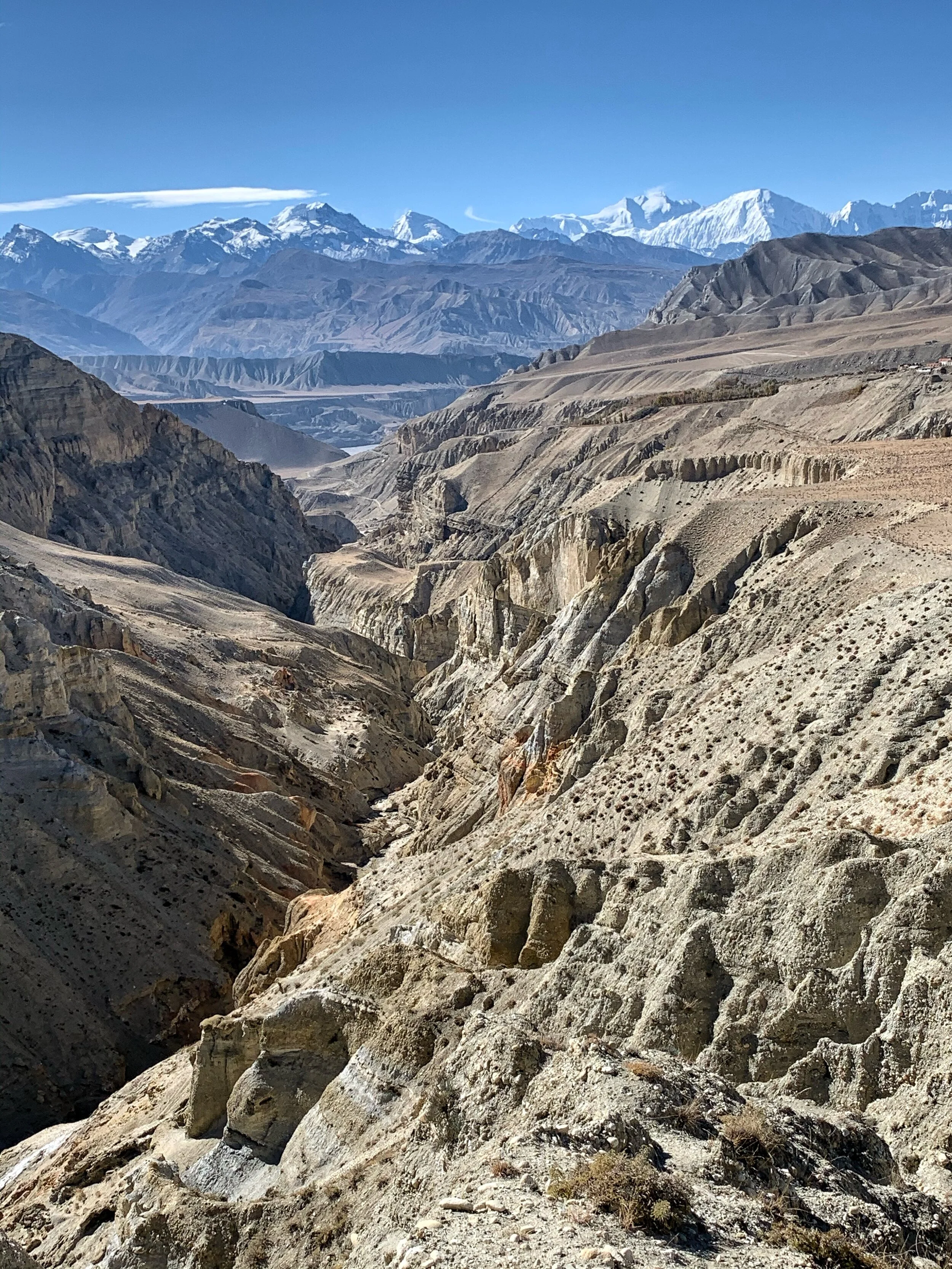
From Dhakmar we traversed the high sandstone formations to get to Tsarang. The trail looked impassible until one rounded a corner and the path revealed itself. This part of the trek was very spectacular.

We ascended to yet another 4,000m pass between Dhakmar and Tsarang. The view of the red cliffs and rock formations was quite impressive.

The view from the pass between Dhakmar and Tsarang looking north-east.

An old way to get around Mustang.

From the pass we could see the north-east wall of Annapurna 1 towering above the Great Barrier (the glaciated white ridge). This view is not visible from the Tilicho Lake or any other location closer to the mountain. We are now more than 60km away from Annapurna. There is a short trek to the west side of Annapurna 1.

Tsarang and its incredible backdrop. Notice the red Gompa on the right side of the photo and the old palace on the centre of the photo.

The royal palace and the monastery of Tsarang. Out of all places in Mustang, I wanted to visit Tsarang the most mainly because of the gompa and its spectacular location. It did not disappoint!

The door chorten of Tsarang (3,560m).

The chorten in front of the Thubten Shedrup Dhargyeling monastery of Tsarang. The monastery was founded in the 16th century and has 60 resident monks of various ages. There is a monastic school next to the monastery. The monks come from Mustang, other areas of Nepal and even Tibet.

The spectacular monastery of Tsarang.

The main prayer hall of the Tsarang monastery. It is not a museum but a functioning religious institution and one needs to ask for a key and a guidance of one of the monks to see the inside of the building. The wall paintings date to the 16th century. Unfortunately some parts of the monastery are left in ruins and are used as storage for building materials.


The roof of the Tsarang monastery. The eight-spoked wheel represents the first turning of the dharma wheel by the Buddha. The male and female deer on the right and left represent the male and female disciples who one-pointedly enjoy and take pleasure in listening to the teachings of the holy dharma.
The interior eight spokes represent the moral conduct of discipline from among the Three Trainings. The intermediate eight spokes represent the training in wisdom and the noble eight-fold path. The outer eight spokes represent the training in meditative concentration.
The entirety of the Buddha’s teachings are contained within the Three Trainings and noble eight-fold path. The pair of deer represent skillful means and wisdom, and based upon the unity of skillful means and wisdom, buddhahood can be attained.

The view from the roof of the Tsarang monastery. Soon we will cross the mountains on the horizon. The Terila Pass is on the left of the photo. The Thorogla Pass that we already crossed on on the right.

The town of Tsarang. The chorten in the village is one of the biggest in Upper Mustang.

The view of the gorge next to the monastery of Tsarang.

Thubten Shedrup Dhargyeling monastery of Tsarang against the spectacular backdrop of the Himalaya.


The main prayer hall of the Tsarang monastery.

The Royal Palace (mostly in ruins after the 2015 earthquake) and the Tsarang monastery.

The spectacular location the Tsarang monastery with the Annapurna mountain range on the horizon. This is the view I was hoping to see!


Spectacular Tsarang

Tsarang monastery, Tilicho Peak and Nilgiri Peak.

The Sumda Chorten is half way between Tsarang and Lo Mantang. The mountains of Thorogla Pass (see Part 1) are right above it.

The road between Tsarang and Lo Mantang, the capital of Mustang. The mountains on the horizon are part of the Mustang Himal and form the border with Tibet. The mountains are all over 6000m in height.

The LoLa Pass 4,000m between Tsarang and Lo Mantang.

The view from LoLa Pass towards Chosar. The area north of Lo Mantang is called Chosar and has many old caves, cave monasteries and old villages. It is only a short distance from the Tibetan border. Apparently you need a special permit to go there but no one asked for it.

The incredible rock formations around Lo Mantang.

The walled city of Lo Mantang seen from Lola Pass. The city is located at an altitude of 3,840m. Its fame is mainly attributable to its remote location and inaccessibility. It reminded me of Timbuktu in Mali. Equally difficult to get to and has many treasures that are not evident at the first glance.

The now deceased King of Lo, Jigme Palbar Bista. Mustang was once an independent kingdom, although closely tied by language and culture to Tibet. From the 15th century to the 17th century, its strategic location granted Mustang control over the trade between the Himalayas and India. At the end of the 18th century the kingdom was annexed by Nepal and became a dependency of the Kingdom of Nepal since 1795.

The chortens and prayer wheels at the entrance to the city of Lo Mantang.

The city gate.

Byams-pa Lhakhang is the oldest temple in Lo Mantang founded in 1447. It is home to the incredible collection Mandala paintings (the best and most impressive I have ever seen). A mandala is a symbolic picture of the universe. It can be a painting on a wall or scroll, created in coloured sands on a table, or a visualisation in the mind of a very skilled adept.
The mandala represents an imaginary palace that is contemplated during meditation. Each object in the palace has significance, representing an aspect of wisdom or reminding the meditator of a guiding principle. The mandala's purpose is to help transform ordinary minds into enlightened ones and to assist with healing.
The Tibetan mandala contains deities, with the principal deity in the centre of the pattern. The deities who reside in the palace embody philosophical views and serve as role models.

The courtyard of the Byams-pa Lhakhang gompa. The door to the lower sanctum was closed and only the upper gallery was open.

Lazy afternoon in the centre of Lo Mantang.

Hanging out and passing time…

The narrow alleys of Lo Mantang


Two large prayer wheels at the entrance to Lo Mantang

Lo Mantang was very quiet. Apparently many locals leave the town for winter and go to Pokhara or Kathmandu. They return in the spring.

The Shakya Chyodi Gompa - founded in 1710 and known as “the new gompa”.

The entrance to the Shakya Chyodi Gompa

The impressive image of the Maitreya Buddha. The temple is also known as the Mandala Temple of Lo Mantang. The walls are painted with 47 magnificent mandalas some of which date back to 15th century. The mandalas are undergoing extensive restoration work by an Italian restorer Luigi Fieni who worked with restoration of the Sistine Chapel in the Vatican.

The massive statues of the Thubchen Lhakhang, the biggest assembly hall in Mustang. The height of the hall is 7.6 meters. The hall is very immersive and on entrance the massive pillars look like a forest.

The murals of the Thubchen Lhakhang temple. The murals are undergoing restoration.

The entrance to the Thubchen Lhakhang temple with massive pillars and statues in the back of the temple.

Inside the Thubchen Lhakhang temple.

Thubchen Lhakhang temple.

Large shortens inside the walled city of Lo Mantang.


Lo Mantang

Lo Mantang

North of Lo Mantang on the way to Chosar.

Long mani wall north of Lo Mantang

Large chorten between Lo Mantang and the cave monastery of Nyiphu.

Near Garphu, the Mustang Range dominates the horizon. The peaks are around 6,000m in height. There is some remote trekking in the range.

Jhong Cave complex. It is around 3,000 years old. One can explore the caves by series of ladders and narrow passages. There is, unfortunately, not much to see inside but the view from the cave complex is spectacular!

The entrance to the Jhong Cave complex.


The view from one of the caves of the Jhong Cave complex.

Exploring the cave complex


Nyiphu Gompa built into the side of a mountain. It is also known as “the cave of the sun”. The monastery dates back to 16th century.

The interior of the Nyiphu temple. The old murals are badly damaged from the smoke from butter lamps.

The view of the Nyiphu temple and the monastic school.

The entrance to the small Graphu Gompa.

Inside the Graphu Gompa

The large cave complex of Gharphu. Unfortunately all caves and temples were closed and the key keeper was impossible to find. It would take a good part of the day to locate the key keeper and explore various caves int he area.

Garphu cave complex

Garphu cave complex

One of many caves that would be fascinating to explore

Garphu
Go to Part 3 Lo Mantang to Terila Pass