August 2/3, 2016 Lima/Callao Peru
We arrived in the port of Callao on a cold and gloomy morning by ship from New York. The sky was overcast and the misty low clouds shrouded the coastal mountains with fog. The port of Callao is far from the city center by bus or taxi. It is thankfully close to the airport and that’s where I was heading. At the airport I met Keith and his girlfriend Kathy, my companions for this part of the journey to Northern Peru. Our plan was to explore the lesser know archeological sites near the city of Chachapoyas.
The city of Chachapoyas is named after an ancient culture of the Chachapoyans that inhabited this region of the Andes. Little is known about them and what is known comes from the accounts of the Spaniards who made the first contact with the Chachapoyans during their conquest of the Inca Empire. The region contains many undiscovered archeological sites that are less known than those around Cusco but not less fascinating or interesting. The region is also not as developed and the tourist infrastructure is in its infancy. English is not spoken and some knowledge of Spanish is necessary.
The city of Chachapoyas is located 450km inland from the Pacific northern coast of Peru. To get to it, one needs to travel by bus through the Andes. There is no airport or railway line so the bus is the only way to go.
After an uneventful flight from Lima to Chicklayo, the starting point for our bus journey, we landed at the half civilian and half military airport. There were many military jets housed under concrete canopies to protect from the ever-present dust and the hot sun.
We were met by a friendly driver who was waiting for us on the instructions from Ernesto, the agency owner from Chachapoyas who was organizing this trip for us.
The driver took us to the bus terminal (a small one for one bus company only). We checked in for our journey to Chachapoyas, left our bags and went for dinner in the center of town. Our first impression of Chiclayo was that is was not a tourist town although the nearby Llayanbeque is where the famous museum of Sipan and Moche Cultures is located. We would explore it on our way back from Chachapoyas.
We walked around Chicklayo in the diminishing daylight. The town was busy with the evening rush hour traffic. The main square had a beautiful municipal palace and a colonial church, which were nicely restored. It was a typical South American Plaza de Armas: old men sitting around, ladies walking arm in arm for an evening stroll, homeless dogs waiting for scraps and vultures circling overhead. As it was getting dark we headed to the recommended restaurant for dinner. We had a good local food as recommended by the driver.
We got back to the bus station at 9pm for the overnight bus to Chachapoyas, located 450km inland and 10 hours away. The bus was surprisingly very good. We sat in the lower deck in the executive class with reclining seats. It was clean and comfortable and after the obligatory loud movie and food we dosed off until we almost reached our destination.
August 3, 2016 Chachapoyas and Kuelap
We arrived in Chachapoyas quite tired after the overnight bus journey. At the bus station we were met by Ernesto and his driver. He took us to the hotel “Villa de Paris” where we checked in and left our bags. The hotel was a beautiful property consisting of a few small buildings with rooms. Flowers and green trees surrounded the property. We had two hours to unpack and rest before we would start our explorations.
After two hours Ernesto collected us to go to the ancient fortress of Kuelap. The fortress is located at an altitude of 3,000m on top of a ridge. In the Peruvian Andes, high ridges and mountaintops are the usual location of ancient ruins. It is often the location of the ruins that makes them so special. Kuelap was no different. The mountain road leading to the citadel of Kuelap snaked along a valley with steep mountains on both sides. The bottom of the valley was at least 1000m down the steep drop-off from the road. Along the way, we passed by a construction site of the Swiss made cable car that will take tourists to the fortress bypassing the road. Although it will make the trip faster, it will also diminish the feel of remoteness, which makes thus place special.


We arrived at the ridge top around noon under gray sky and rain-threatening clouds. There were no other foreign tourists at all, only a few Peruvians. From the parking lot we had to hike up to the imposing 30 feet high walls surrounding the citadel of Kuelap. The site has only one accessible entrance through the ancient gate to the city. The site is not thoroughly excavated and hides many mysteries and secrets under the tick vegetation.

The citadel of Kuelap was built between 600 and 900 years before Machu Picchu. It’s located on a higher mountain and is a larger than Machu Picchu. Just 30 years ago the trek from Kuelap to the nearest road took a staggering two months to complete.
The citadel is surrounded by steep walls and has only two entrances allowing access. One of the entrances is crumbling and the walls in this area were reinforced with timber beams. It is not safe to use so only one access point remains. In its glory days, it is estimate that 5000 people lived inside the citadel. The inhabitants were known as the Cloud Warriors. The Cloud Warriors were conquered by the Incas in 1470 (who in turn were conquered by the Spanish 70 years later).
The citadel of Kuelap was very interesting. Not much is known about the Chachapoyans and to this day, the exact purpose of the citadel is not known. The Chachapoyans had contact with the Spanish and the Incas. They actually aligned with the Spanish to fight against the Incas. We wandered around the ruins and the rebuilt circular houses of the Chachapoyans. There is also one Inca structure of unknown origin and purpose. One distinguishing feature of the Chachapoyan architecture is the geometrical pattern on the circular houses symbolizing the jaguar and snakes (the animals which were revered for their strength).

After Kuelap we stopped for late lunch in a small town where Keith had his first coy (Guinea Pig, also the food of the ancient Chachapoyans). Later that day we ended up in a local coffee shop in the main square of Chachapoyas for excellent coffee, pisco sour and an apple pie.
August 4, 2016 Chachapoyas and Karaja
Today we went to a mountain burial site of Karaja. The journey from Chachapoyas took 2 hours by car followed by an hour walk through cornfields.


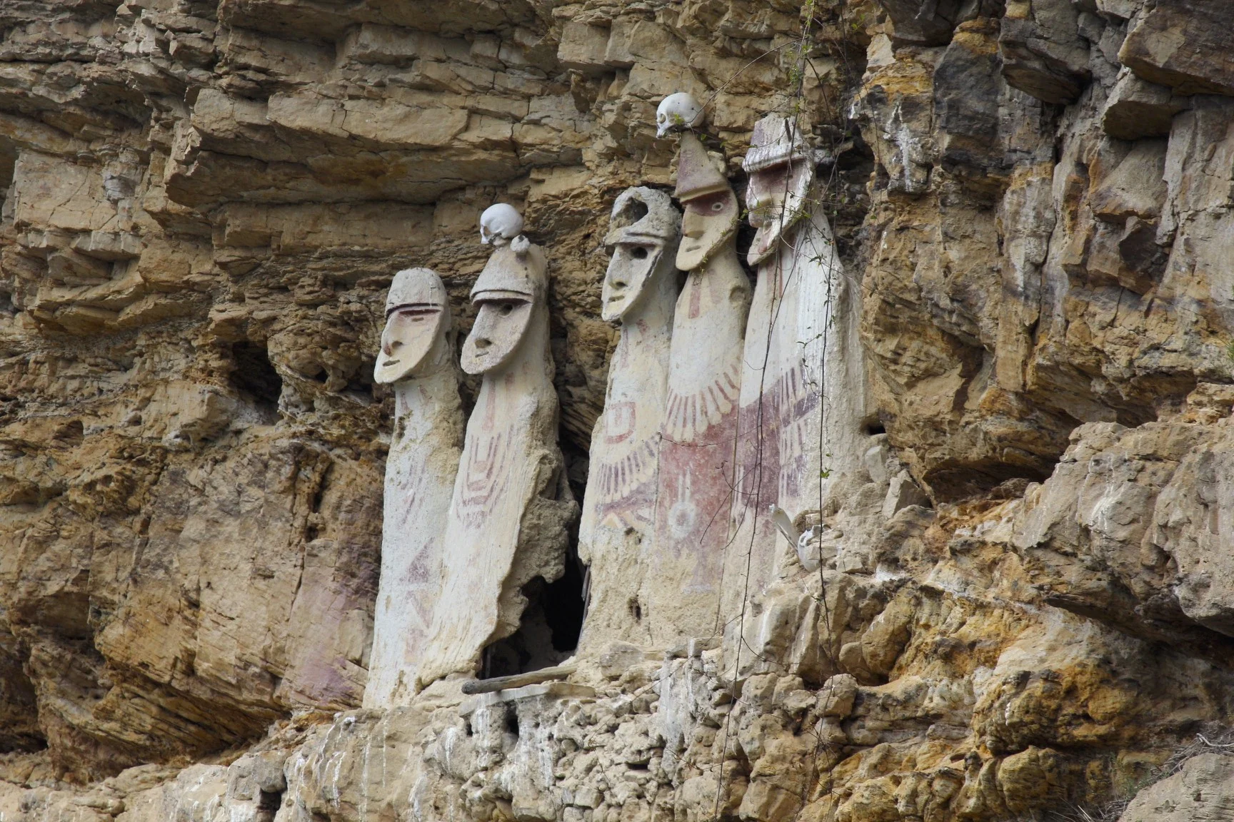
Karaja is an old burial site located on a steep ravine. The sarcophagi of Karaja are often used as a symbol of the tourism in the region. They are very striking in their design. They are 2.5 meters tall effigies of human figures with characteristic faces reminiscent of the Rapa Nui Moai statues. They are painted in white and red and adorned with human skulls.

Unfortunately, the sarcophagi located on the cliff have been looted – a common occurrence in Peru. It was hard to see the sarcophagi from the bottom of the cliff and I had to use my log telephoto lens to get a better view. This was probably the least interesting of all the sites around Chachapoyas. It is a long drive from the city and the site is actually very small. Never the less, the story surrounding the site and the difficulty of access to the sarcophagi is worth seeing. At the bottom of the cliff we saw a bundle of human bones that were dropped by the looters as they opened the burial sites on the cliffs. It was interesting to see the country site along our drive and to see the small town near the archeological site. We had a chance to meet some locals and have lunch at one of the local eateries. The site is not developed for tourism at all and does not offer any amenities.

After our excursion we had a nice dinner in an asado restaurant in Chachapoyas. We ate some mystery meats, drank cold beer and listened to live Peruvian music. All that for $15 for 4 people! Obviously the mass tourism and its prices have not arrived here yet. The town of Chachapyas does not have any visible signs of affluence, no fancy shops, no expensive restaurants or fancy cars. Everything is inexpensive and the people here are very nice, down to earth and friendly. It is more similar to Bolivia and very different from Cusco. It is also safe with almost no violent crime. The city of Chachapoyas was established at the same time as Lima. Wile Lima grew to a multi million metropolis, Chachapoyas stayed at 30,000 people. It is the administrative capital of the province of Amazonas although due to its altitude of 2300m it does not feel very tropical.
August 5, 2016 Revash and The Museum Leymebamba
Today we took another 2-hour drive to Revash. Revash is another interesting burial mausoleum. On the way to Revash we spotted many burial sites dotting the high cliffs. Revash is located on a high, long escarpment overlooking a broad valley. The road to Revash is very spectacular climbing up among the mountains. The views got progressively better as we gained altitude. I found it remarkable that the locals cultivate all mountain slopes sometimes at a steep angle with no terracing so common in the Inca territories.

The parking for the archeological site of Revash is in a non descript village with no souvenir shops of any kind. Again, a clear sign of little tourism in this area.
We had to hike to the cliffs along a large sidewalk built by the locals.
The Revash mausoleum reminded me of the cliff dwellings of the Anasazi Indians in the Canyon de Chey in Arizona (apparently there is no real connection). The site is very spectacular with imposing views to the valley below. Not much is known about the Revash culture. The mausoleum had nothing left in it after it was looted. It is actually closed to intruders and the visitors can only admire it from below from the specially built platform. The mausoleum consists of small house-like structures with symbolic roofs located in a cave on a steep wall of a long canyon. The walls of the mausoleum’s houses are adorned with paintings of animal figures and some geometric shapes. At the time of use, mummies were placed inside the houses. Again, it is the location of the mausoleum and the spectacular surroundings that make this place so special.


After Revash, we drove to the village of Leymebamba to see the fantastic museum of the mummies found in a site called Laguna de Condores. The museum contains amazing artifacts that were found along the 220 mummy bundles by the lake called Laguna de Condores in 1997. The mummies were found by the local farmers who attempted to sell the mummies for $200 a piece. The local authorities intersected the sale and thankfully retrieved the remaining artifacts intact. The find was so spectacular that an entire museum was built to house it. This was the first major site that was not looted and it gave many clues to the mysteries of the Chachapoyan culture. It also legitimized the Chachapoyans as a distinct culture in the scientific circles.
“This museum was built to provide a place for the preservation of the mummies and archaeological materials recovered from Laguna de los Cóndores in 1997. This work was conducted by Centro Mallqui with contributions from the international community from Austria, Finland, Italy and the U.S., as well as significant contributions from the Institute for Bioarchaeology, the von Hagen family and the Discovery Channel.
The local community contributed with building materials and labour. The people of Leymebamba own the museum and are represented by a civil identity. Centro Mallqui runs the professional and administrative work of the facility. It was inaugurated in 2000 with the presence of the Minister of Education of Austria, Dr. Elisabeth Gehrer. The museum was built using local construction techniques like packed earth with wood and tile roofs. These were complemented by modern technical resources to meet the conservation and exhibition requirements for archaeological materials.
Most of the cultural remains on display are Chachapoya and are from the time of Inca domination in the area. It also has a room dedicated to traditional cultural continuity in the region.” From the museum webpage www.museoleymebamba.org
When we arrived at the museum there was no one around. Ernesto had to find the key keeper to open the museum for us. Later, we met 3 French travelers who made their way from the French Guiana up the Amazon River. They had lots of time, little money and many interesting stories. One of the highlights of their trip was hiking the Roirama on the Venezuela/Brasil border.
We were not allowed to photograph inside the museum but I could not resist sneaking a few photos of the mummies and the most interesting displays. It was one of the most interesting museums in Peru. The mummies were all housed in a special temperature controlled chamber in the exact state that they were discovered. They were placed on shelves 4 levels high. Only a few bundles were unwrapped and analyzed. Given the massive amount of material from this find, the archeologists will be busy for many years. Some of the unwrapped mummies were on display as well. The mummy bundles had effigies of human faces pained on them and their grotesque expressions looked spooky. It was difficult to imagine that these were once proud living beings with their own dreams and ambitions. They all must have been well to do as the peasants and commoners do not get mummified and placed in mausoleums. Asi es la vida – literally!
“The Mummies of the Laguna de los Cóndores
The preservation of the human remains from the Laguna de los Cóndores is extraordinary. What could account for such preservation in an area of high rainfall and humidity? In spite of the rainy climate and the water, which often falls in sheets from the overhand protecting the chullpas, the dry ledge where the chullpas are located harbors and dry and cold microclimate that contributed to the preservation of the organic remains. The Chachapoya appear not to have embalmed their dead; rather, they deliberately chose burial sites whose microclimates enhanced preservation. The evidence suggests that it was the Inca who introduced the Chachapoya to procedures such as embalming and evisceration.
Preliminary studies point to the skill of the Laguna de los Cóndores embalmers. The skin of the mummies has been treated and appears leathery, while unspun cotton placed under the cheeks, in the mouth and in the nostrils, preserved facial features. They controlled decomposition by emptying the abdominal cavity through the anus, sealing the orifice with a cloth plug. The bodies had been reduced to their minimum volume and weight: joints are strained to the point that the flexed position is almost unnatural. Finally, the bodies were wrapped in layers of cloth, creating a microclimate that promoted conservation.”
The Laguna de los Cóndores
Deep in the cloud forest blanketing the eastern slopes of the Huallaga watershed, a row of stone burial houses perches high above a lake. Tucked into a ledge on a limestone cliff 100 meters above the Laguna de los Cóndores, the structures stood untouched by humans for almost 500 years. Composed of six intact chullpas or tombs and the foundations of a seventh, the burial site is one of 18 funerary sites documented on the limestone cliffs looming above the Laguna de los Cóndores. Although the farm hands who had discovered the burial site in late 1996 churned through the tombs, slashing mummy bundles with machetes and destroying valuable contextual information, the more than 200 mummy bundles and a wide array of burial offerings indicate that the finds date to Chachapoya (ca. AD 800-1470), Chachapoya-Inca (ca. 1470-1532) and early Colonial (ca. 1532-1570) times.
The tombs’ builders took advantage of a natural ledge in the limestone cliff. The tombs are nestled against the cliff, which serves as their back wall. The builders modified the ledge by levelling the floor and carving smaller ledges into the cliff onto which they built low masonry walls set in mud mortar that supported the back roofs of the chullpas. Each tomb is about 3 meters high and divided into two levels by a platform of small logs. The structures are roughly quadrangular in shape and built of limestone blocks set in mud mortar. All the chullpas face the lake and the ancient settlement of Llaqtacocha.” From the museum’s website

It makes me wander what the life’s struggle all about – looking at these forgotten people, forgotten nation, nothing is known of them. Who were the Chachapoyans? All that is left is the room full of dead and many mysteries.
The museum also contained fine Inca weavings preserved in excellent condition and beautifully displayed. Also, there were many items of Inca pottery, headdresses with plumage from the Amazon and Inca knot writing.

After spending last few days looking at various archeological sites, ruins, excavated mummies and looted sarcophagi, I concluded that Northern Peru is fascinating. The sheer number of interesting places, the history, the mysteries and the enigma surrounding these people was mind-boggling.
August 6, 2016 Gocta Waterfall
Gocta Waterfall is the 3rd highest waterfall in the World. In order to get to it, we drove for a short distance from Chachapoyas in the opposite direction from Kuelap. On the way we stopped at a small site with ancient petroglyphs that are a few thousand years old. Another mystery as not much is known about them. We drove down a spectacular river valley with high rocky cliffs towering above us on both sides. In some places, the canyon was so narrow that the road builders had to blast a near tunnel though the rock. It was very scenic and reminded me of the Karakoram Highway in Pakistan.
After a short drive (40-50km) we turned onto a gravel road that took us uphill to the trailhead to the falls. The hike to the base of the falls is 6 km through a temperate forest full of palms, coffee plants and other tropical vegetation. The waterfall consists of 2 separate parts: the upper falls 300m high and the lower falls 500m high. Only from far away both parts of the waterfall are visible. The slender white ribbon of water cascades from the high cliff to the lush valley below. The water comes from a series of lakes fed by rainwater. The ground surrounding the lakes is like a sponge so the water continuously seeps through feeding the lakes and the waterfall.

Once we got closer to the waterfall the upper part disappeared from view. The hike was surprisingly strenuous with the total elevation gain of 800m through s series of ups and downs some of which were quite steep and long.
Ernesto and I conversed in Spanish surprisingly well and I managed to get my point across on variety of subjects.
The waterfall is located at the head of a long valley and is surrounded by a circular escarpment. Due to almost constant mist from the falling water and spray the vertical cliffs are overgrown by moss and vegetation. The green walls give the cirque a tropical look with the water of the Gocta Falls falling from great heights and other numerous smaller falls dripping down all around. Apparently during the rainy season, the waterfall is so powerful that it is impossible to approach it. I wanted to stay longer and take it all in but everyone wanted to go back.


After returning to Chachapoyas we ended up in the now familiar coffee shop. We were lucky to see a great performance of local musicians playing fusion of great Peruvian traditional music and modern tunes. We were the only spectators and the musicians had as good or better time than us.
August 7, 2016 Chachapoyas
Today was our last day in the beautiful Chachapoyas. We started the day with a drive to an awesome canyon with sweeping views to the valley down below. The sky was metallic grey with angry clouds and strong wind. The surrounding country looked wild, cold and uninviting although beautiful and mysterious. It was difficult to believe that we were so close to the Amazon rainforest. We were alone on the edge of this deep canyon looking down at the the river over 1km below. Near the parking lot there was a concrete observation tower where a lone lady from a nearby village was selling souvenirs and gave us a pottery making demonstration. It was quite interesting to see especially considering that she did not use a wheel to turn the pottery. The pottery was baked in an open fire and not in an enclosed kiln.

We drove on to another high viewpoint even more spectacular. The view extended over the entire region from this high point. We could see various villages that we passed on our way to see many archeological points of interest during our stay here. In the distance we could even see the Gocta Waterfall. All these high ridges (some are 4000m high) are criss crossed by a network of old tracks that the ancients and the contemporary inhabitants used to get around. The weather was not the best for photography but it was an incredible place to see and admire. We passed through some overgrown and unexcavated ruins waiting for future excavation.
After the tour of the various viewpoints we stopped at a local fair with numerous stalls selling local products such as chocolate, coffee and vine. The air also had performances by local dancer and musicians. We then returned to Chachapoyas for the overnight 10-hour ride back to Chicklayo.
August 8, 2016 Chicklayo – Sipan
We had some time in Chicklayo before our flight to Lima so we hired a car and a guide to take us to the nearby Huaca Rajada, famous for the tombs of the Lord of Sipan. The flat desert plain of coastal Peru was home to the Moche culture (among many others). The tomb of the Lord of Sipan was discovered in 1987 and I remember reading about it in the National Geographic magazine. The find contained the most amount of gold ever found in the Americas and only second to the tomb of Tutankhamen in the quantity of gold found in the world.
“Scientific analysis of the skeleton of the Lord of Sipán show that he was approximately 1.63 meters tall and was about 35–45 years old at the time of his death. His jewellery and ornaments, which included headdresses, a face mask, a pectoral, (the pectoral was gold and had the head of a man and the body of an octopus) necklaces, nose rings, ear rings and other items, indicate he was of the highest rank. Most of the ornaments were made of gold, silver, copper and semi-precious stones.
The Lord of Sipán was wearing two necklaces with beads of gold and silver in the shape of maní (peanuts), which represent the tierra (earth). The peanuts symbolized that men came from the land, and that when they die, they return to the earth. Peanuts were used because they were an important food crop for the Moche. The necklaces had ten kernels on the right side made of gold, signifying masculinity and the sun god, and ten kernels on the left side made of silver, to represent femininity and the moon god.
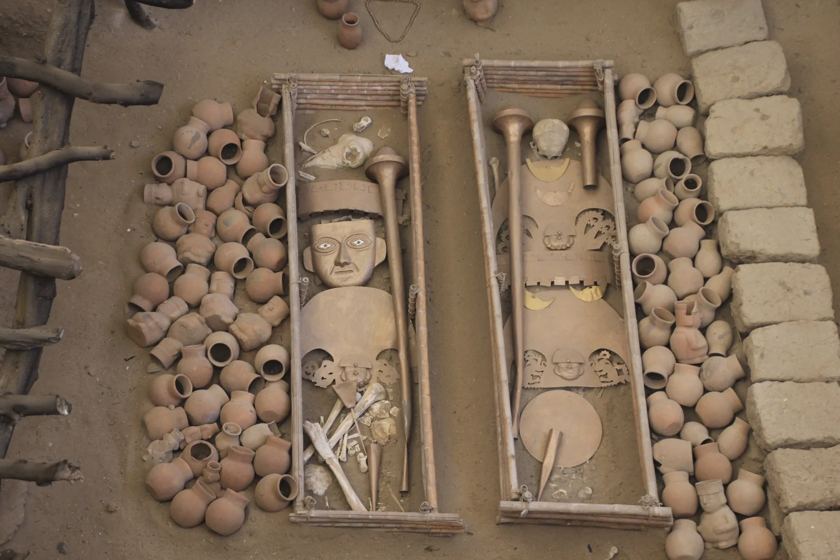
Buried with the Lord of Sipán were six other people: three young women (possibly wives or concubines who had apparently died some time earlier), two males (probably warriors), and a child of about nine or ten years of age. The remains of a third male (possibly also a warrior) was found on the roof of the burial chamber sitting in a niche overlooking the chamber. There was also a dog, which was probably the Lord of Sipan's favourite pet. The warriors who were buried with the Lord of Sipán had amputated feet, as if to prevent them from leaving the tomb. The women were dressed in ceremonial clothes. In addition to the people, archaeologists found in the tomb a total of 451 ceremonial items and offerings, and the remains of several animals, including a dog and two llamas.”
The site is 70km from Chicklayo on a dusty desert plain. It is vary hot here! The villages that we passed on the way to Huaca Rajada (the site of the tombs) were very poor. The tom was discovered by one of the peasants from the nearby village who was looking for gold. The existence of old burial sites was known to the locals and they were actively looking for them. After the villagers discovered the tomb, the local police raided the house of the man who found it, killed him and sold the gold to a private collector.
The site consists of 14 gravesites. The gold and artifacts were removed and placed in the nearby museum. The bodies and the artifacts were replaced with replicas to show the exact state and condition they were found in. The replicas show all the gold, position of the bodies of the kings and the people that were buried with them. Each gravesite has a display describing in great detail the contents and composition of each site. Among the gravesites are two adobe pyramids that were used as a burial platform by the Moche people.


At the site, there is a great museum showing actual contents of one of the lesser tombs. Even this lesser tomb filled up the entire museum with the actual skeleton, gold, copper, pottery and other items. It was all very interesting and difficult to fathom that in the middle of such poverty, there was so much gold and opulence of the royals.
The contents of the main tomb of the Lord of Sipan are in the museum in Lambayeque. Unfortunately it was Monday and the museum was closed. We did visit another museum of Bruning. The museum was based on a collection of a German man, Bruning, who purchased many artifacts from the locals (most likely looted). The museum was filled with so much gold that it did not seem real. In the basement of the museum, newly discovered contents of a burial site of a Moche Queen were on display. The tomb was discovered in 2015. It was discovered intact and was not looted.


